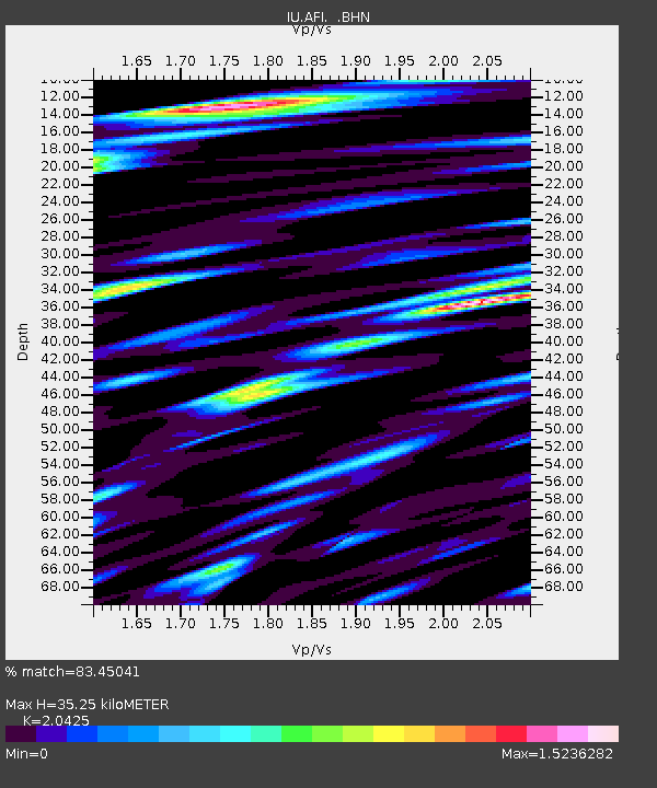
AFI Afiamalu, Western Samoa - Earthquake Result Viewer

Earthquake location: Eastern New Guinea Reg., P.N.G.
Earthquake latitude/longitude: -5.9/146.0
Earthquake time(UTC): 1993/10/25 (298) 10:27:01 GMT
Earthquake Depth: 10 km
Earthquake Magnitude: 6.4 MB, 7.1 MS, 7.1 UNKNOWN, 6.7 MW
Earthquake Catalog/Contributor: WHDF/NEIC
Network: IU Global Seismograph Network (GSN - IRIS/USGS)
Station: AFI Afiamalu, Western Samoa
Lat/Lon: 13.91 S/171.78 W
Elevation: 706 m
Distance: 42.3 deg
Az: 104.132 deg
Baz: 276.566 deg
Ray Param: 0.0732585
Estimated Moho Depth: 35.25 km
Estimated Crust Vp/Vs: 2.04
Assumed Crust Vp: 4.24 km/s
Estimated Crust Vs: 2.076 km/s
Estimated Crust Poisson's Ratio: 0.34
Radial Match: 83.45041 %
Radial Bump: 400
Transverse Match: 74.27758 %
Transverse Bump: 400
SOD ConfigId: 16938
Insert Time: 2010-03-02 01:43:25.596 +0000
GWidth: 2.5
Max Bumps: 400
Tol: 0.001

Signal To Noise

ChannelStoNSTALTA
IU:AFI: :BHN:19931025T10:34:24.303009Z0.77736191.233993E-61.5874111E-6
IU:AFI: :BHE:19931025T10:34:24.303009Z1.18896872.0277998E-61.7055115E-6
IU:AFI: :BHZ:19931025T10:34:24.303009Z2.23955463.4995778E-61.5626222E-6
Arrivals
Ps8.9 SECOND
PpPs25 SECOND
PsPs/PpSs34 SECOND