You are here: Home > Network List > TA - USArray Transportable Network (new EarthScope stations) Stations List
> Station G05D Wamic, OR, USA > Earthquake Result Viewer
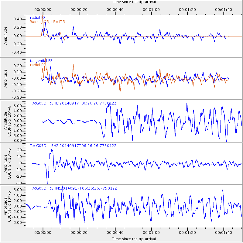
G05D Wamic, OR, USA - Earthquake Result Viewer
*The percent match for this event was below the threshold and hence no stack was calculated.
| Earthquake location: |
Mariana Islands |
| Earthquake latitude/longitude: |
13.8/144.4 |
| Earthquake time(UTC): |
2014/09/17 (260) 06:14:46 GMT |
| Earthquake Depth: |
137 km |
| Earthquake Magnitude: |
6.7 MWC, 7.1 MI |
| Earthquake Catalog/Contributor: |
NEIC PDE/NEIC COMCAT |
|
| Network: |
TA USArray Transportable Network (new EarthScope stations) |
| Station: |
G05D Wamic, OR, USA |
| Lat/Lon: |
45.24 N/121.32 W |
| Elevation: |
592 m |
|
| Distance: |
83.3 deg |
| Az: |
45.178 deg |
| Baz: |
282.698 deg |
| Ray Param: |
$rayparam |
*The percent match for this event was below the threshold and hence was not used in the summary stack. |
|
| Radial Match: |
81.736694 % |
| Radial Bump: |
351 |
| Transverse Match: |
79.26336 % |
| Transverse Bump: |
400 |
| SOD ConfigId: |
795072 |
| Insert Time: |
2014-10-01 07:56:27.816 +0000 |
| GWidth: |
2.5 |
| Max Bumps: |
400 |
| Tol: |
0.001 |
|
Signal To Noise
| Channel | StoN | STA | LTA |
| TA:G05D: :BHZ:20140917T06:26:26.775012Z | 47.79578 | 1.4147743E-5 | 2.9600403E-7 |
| TA:G05D: :BHN:20140917T06:26:26.775012Z | 2.178595 | 9.3449626E-7 | 4.2894445E-7 |
| TA:G05D: :BHE:20140917T06:26:26.775012Z | 6.2551966 | 3.1414972E-6 | 5.0222195E-7 |
| Arrivals |
| Ps | |
| PpPs | |
| PsPs/PpSs | |


