You are here: Home > Network List > TA - USArray Transportable Network (new EarthScope stations) Stations List
> Station HDA Harding Lake, AK, USA > Earthquake Result Viewer
HDA Harding Lake, AK, USA - Earthquake Result Viewer

| Earthquake location: |
Mariana Islands |
| Earthquake latitude/longitude: |
13.8/144.4 |
| Earthquake time(UTC): |
2014/09/17 (260) 06:14:46 GMT |
| Earthquake Depth: |
137 km |
| Earthquake Magnitude: |
6.7 MWC, 7.1 MI |
| Earthquake Catalog/Contributor: |
NEIC PDE/NEIC COMCAT |
|
| Network: |
TA USArray Transportable Network (new EarthScope stations) |
| Station: |
HDA Harding Lake, AK, USA |
| Lat/Lon: |
64.41 N/146.95 W |
| Elevation: |
437 m |
|
| Distance: |
68.5 deg |
| Az: |
25.77 deg |
| Baz: |
256.578 deg |
| Ray Param: |
0.05589489 |
| Estimated Moho Depth: |
28.0 km |
| Estimated Crust Vp/Vs: |
1.80 |
| Assumed Crust Vp: |
6.566 km/s |
| Estimated Crust Vs: |
3.643 km/s |
| Estimated Crust Poisson's Ratio: |
0.28 |
|
| Radial Match: |
90.64241 % |
| Radial Bump: |
400 |
| Transverse Match: |
75.96735 % |
| Transverse Bump: |
400 |
| SOD ConfigId: |
795072 |
| Insert Time: |
2014-10-01 07:56:37.518 +0000 |
| GWidth: |
2.5 |
| Max Bumps: |
400 |
| Tol: |
0.001 |
|
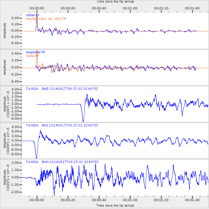
Signal To Noise
| Channel | StoN | STA | LTA |
| TA:HDA: :BHZ:20140917T06:25:02.924976Z | 66.43371 | 5.8380906E-6 | 8.787844E-8 |
| TA:HDA: :BHN:20140917T06:25:02.924976Z | 8.605152 | 6.374283E-7 | 7.4075196E-8 |
| TA:HDA: :BHE:20140917T06:25:02.924976Z | 33.5417 | 2.2822237E-6 | 6.804139E-8 |
| Arrivals |
| Ps | 3.6 SECOND |
| PpPs | 11 SECOND |
| PsPs/PpSs | 15 SECOND |


