You are here: Home > Network List > IU - Global Seismograph Network (GSN - IRIS/USGS) Stations List
> Station AFI Afiamalu, Western Samoa > Earthquake Result Viewer
AFI Afiamalu, Western Samoa - Earthquake Result Viewer
| Earthquake location: |
Solomon Islands |
| Earthquake latitude/longitude: |
-5.8/154.2 |
| Earthquake time(UTC): |
1995/08/16 (228) 10:27:26 GMT |
| Earthquake Depth: |
16 km |
| Earthquake Magnitude: |
6.4 MB, 7.8 MS, 7.8 UNKNOWN, 7.8 MW |
| Earthquake Catalog/Contributor: |
WHDF/NEIC |
|
| Network: |
IU Global Seismograph Network (GSN - IRIS/USGS) |
| Station: |
AFI Afiamalu, Western Samoa |
| Lat/Lon: |
13.91 S/171.78 W |
| Elevation: |
706 m |
|
| Distance: |
34.4 deg |
| Az: |
106.096 deg |
| Baz: |
280.124 deg |
| Ray Param: |
0.07773465 |
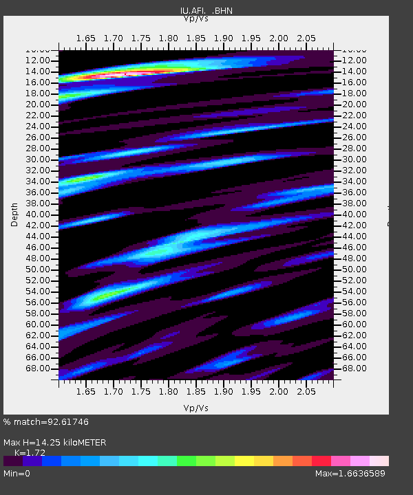
| Estimated Moho Depth: |
14.25 km |
| Estimated Crust Vp/Vs: |
1.72 |
| Assumed Crust Vp: |
4.24 km/s |
| Estimated Crust Vs: |
2.465 km/s |
| Estimated Crust Poisson's Ratio: |
0.24 |
|
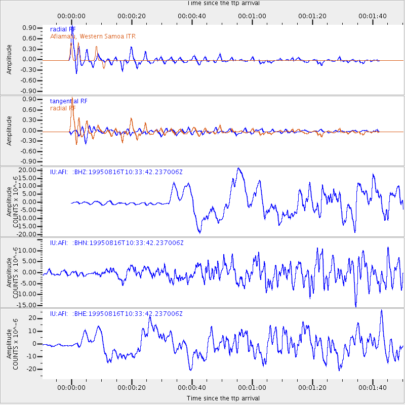
| Radial Match: |
92.61746 % |
| Radial Bump: |
400 |
| Transverse Match: |
66.238174 % |
| Transverse Bump: |
400 |
| SOD ConfigId: |
6273 |
| Insert Time: |
2010-03-02 01:43:27.190 +0000 |
| GWidth: |
2.5 |
| Max Bumps: |
400 |
| Tol: |
0.001 |
|
Signal To Noise
| Channel | StoN | STA | LTA |
| IU:AFI: :BHN:19950816T10:33:42.237006Z | 0.8111087 | 8.0985393E-7 | 9.98453E-7 |
| IU:AFI: :BHE:19950816T10:33:42.237006Z | 8.367178 | 4.6173705E-6 | 5.518432E-7 |
| IU:AFI: :BHZ:19950816T10:33:42.237006Z | 9.033749 | 5.7183743E-6 | 6.3300126E-7 |
| Arrivals |
| Ps | 2.5 SECOND |
| PpPs | 8.8 SECOND |
| PsPs/PpSs | 11 SECOND |


