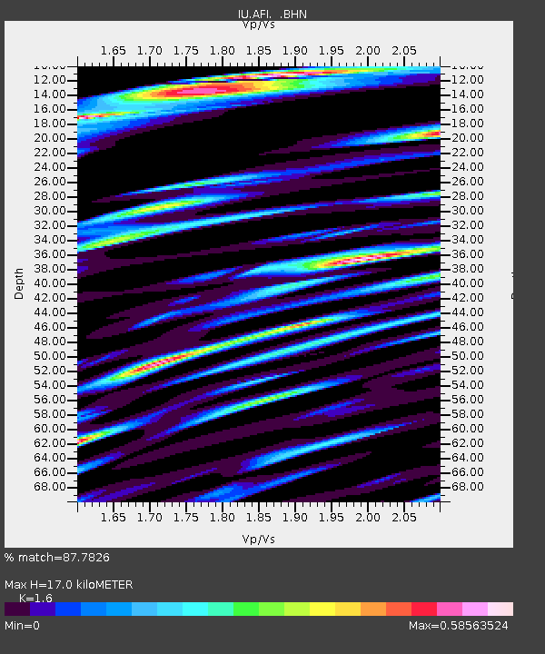
AFI Afiamalu, Western Samoa - Earthquake Result Viewer

Earthquake location: New Britain Region, P.N.G.
Earthquake latitude/longitude: -4.8/151.5
Earthquake time(UTC): 1995/08/14 (226) 04:37:17 GMT
Earthquake Depth: 126 km
Earthquake Magnitude: 6.3 MB, 6.3 MS, 6.4 UNKNOWN
Earthquake Catalog/Contributor: WHDF/NEIC
Network: IU Global Seismograph Network (GSN - IRIS/USGS)
Station: AFI Afiamalu, Western Samoa
Lat/Lon: 13.91 S/171.78 W
Elevation: 706 m
Distance: 37.3 deg
Az: 106.591 deg
Baz: 280.428 deg
Ray Param: 0.07578275
Estimated Moho Depth: 17.0 km
Estimated Crust Vp/Vs: 1.60
Assumed Crust Vp: 4.24 km/s
Estimated Crust Vs: 2.65 km/s
Estimated Crust Poisson's Ratio: 0.18
Radial Match: 87.7826 %
Radial Bump: 399
Transverse Match: 74.880486 %
Transverse Bump: 400
SOD ConfigId: 6273
Insert Time: 2010-03-02 01:43:29.157 +0000
GWidth: 2.5
Max Bumps: 400
Tol: 0.001

Signal To Noise

ChannelStoNSTALTA
IU:AFI: :BHN:19950814T04:43:46.694012Z1.00885381.1432977E-61.133264E-6
IU:AFI: :BHE:19950814T04:43:46.694012Z12.2191546.204092E-65.07735E-7
IU:AFI: :BHZ:19950814T04:43:46.694012Z16.208636.7911706E-64.1898485E-7
Arrivals
Ps2.5 SECOND
PpPs10 SECOND
PsPs/PpSs13 SECOND