You are here: Home > Network List > TA - USArray Transportable Network (new EarthScope stations) Stations List
> Station K02D Willamette Meridian, OR, USA > Earthquake Result Viewer
K02D Willamette Meridian, OR, USA - Earthquake Result Viewer
| Earthquake location: |
Mariana Islands |
| Earthquake latitude/longitude: |
13.8/144.4 |
| Earthquake time(UTC): |
2014/09/17 (260) 06:14:46 GMT |
| Earthquake Depth: |
137 km |
| Earthquake Magnitude: |
6.7 MWC, 7.1 MI |
| Earthquake Catalog/Contributor: |
NEIC PDE/NEIC COMCAT |
|
| Network: |
TA USArray Transportable Network (new EarthScope stations) |
| Station: |
K02D Willamette Meridian, OR, USA |
| Lat/Lon: |
42.70 N/123.67 W |
| Elevation: |
989 m |
|
| Distance: |
82.2 deg |
| Az: |
48.044 deg |
| Baz: |
281.433 deg |
| Ray Param: |
0.0467274 |
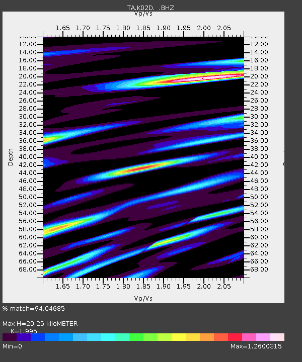
| Estimated Moho Depth: |
20.25 km |
| Estimated Crust Vp/Vs: |
2.00 |
| Assumed Crust Vp: |
6.522 km/s |
| Estimated Crust Vs: |
3.269 km/s |
| Estimated Crust Poisson's Ratio: |
0.33 |
|
| Radial Match: |
94.04685 % |
| Radial Bump: |
400 |
| Transverse Match: |
89.17344 % |
| Transverse Bump: |
400 |
| SOD ConfigId: |
795072 |
| Insert Time: |
2014-10-01 07:57:07.786 +0000 |
| GWidth: |
2.5 |
| Max Bumps: |
400 |
| Tol: |
0.001 |
|
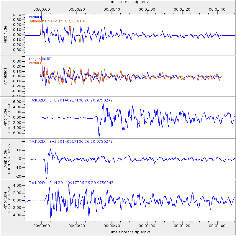
Signal To Noise
| Channel | StoN | STA | LTA |
| TA:K02D: :BHZ:20140917T06:26:20.975024Z | 37.701416 | 8.935291E-6 | 2.3700147E-7 |
| TA:K02D: :BHN:20140917T06:26:20.975024Z | 5.999781 | 1.2145417E-6 | 2.02431E-7 |
| TA:K02D: :BHE:20140917T06:26:20.975024Z | 19.581377 | 2.9100254E-6 | 1.4861189E-7 |
| Arrivals |
| Ps | 3.2 SECOND |
| PpPs | 9.1 SECOND |
| PsPs/PpSs | 12 SECOND |


