You are here: Home > Network List > TA - USArray Transportable Network (new EarthScope stations) Stations List
> Station N02D Trinity Center, CA, USA > Earthquake Result Viewer
N02D Trinity Center, CA, USA - Earthquake Result Viewer
| Earthquake location: |
Mariana Islands |
| Earthquake latitude/longitude: |
13.8/144.4 |
| Earthquake time(UTC): |
2014/09/17 (260) 06:14:46 GMT |
| Earthquake Depth: |
137 km |
| Earthquake Magnitude: |
6.7 MWC, 7.1 MI |
| Earthquake Catalog/Contributor: |
NEIC PDE/NEIC COMCAT |
|
| Network: |
TA USArray Transportable Network (new EarthScope stations) |
| Station: |
N02D Trinity Center, CA, USA |
| Lat/Lon: |
40.97 N/122.71 W |
| Elevation: |
937 m |
|
| Distance: |
83.3 deg |
| Az: |
49.593 deg |
| Baz: |
282.266 deg |
| Ray Param: |
0.04599039 |
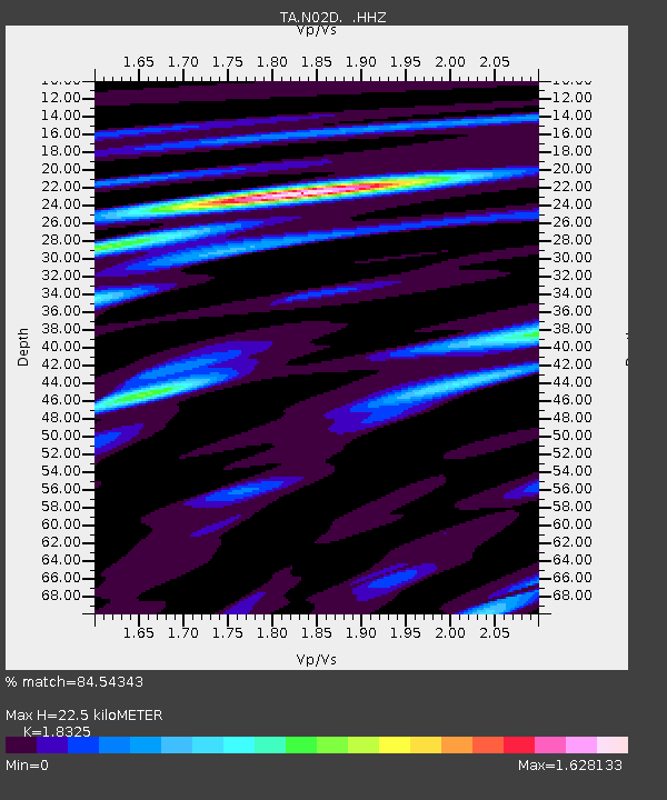
| Estimated Moho Depth: |
22.5 km |
| Estimated Crust Vp/Vs: |
1.83 |
| Assumed Crust Vp: |
6.566 km/s |
| Estimated Crust Vs: |
3.583 km/s |
| Estimated Crust Poisson's Ratio: |
0.29 |
|
| Radial Match: |
84.54343 % |
| Radial Bump: |
400 |
| Transverse Match: |
86.34512 % |
| Transverse Bump: |
400 |
| SOD ConfigId: |
795072 |
| Insert Time: |
2014-10-01 07:57:37.435 +0000 |
| GWidth: |
2.5 |
| Max Bumps: |
400 |
| Tol: |
0.001 |
|
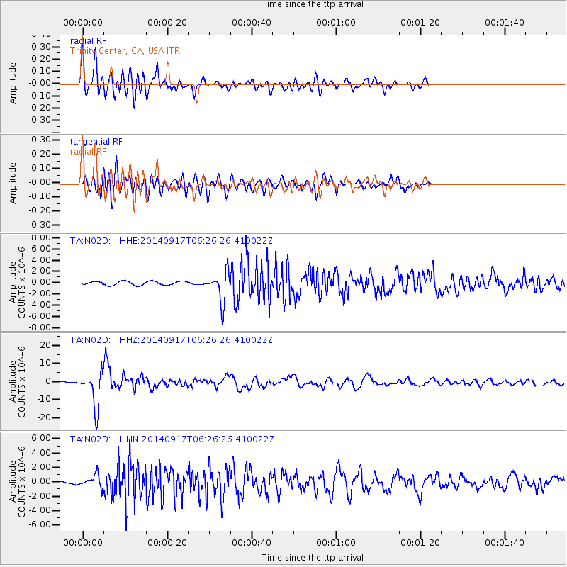
Signal To Noise
| Channel | StoN | STA | LTA |
| TA:N02D: :HHZ:20140917T06:26:26.410022Z | 25.696953 | 9.778165E-6 | 3.8051846E-7 |
| TA:N02D: :HHN:20140917T06:26:26.410022Z | 2.9263713 | 8.7032817E-7 | 2.9740866E-7 |
| TA:N02D: :HHE:20140917T06:26:26.410022Z | 8.287565 | 2.745176E-6 | 3.3124036E-7 |
| Arrivals |
| Ps | 2.9 SECOND |
| PpPs | 9.5 SECOND |
| PsPs/PpSs | 12 SECOND |


