You are here: Home > Network List > AK - Alaska Regional Network Stations List
> Station CUT Chulitna, AK, USA > Earthquake Result Viewer
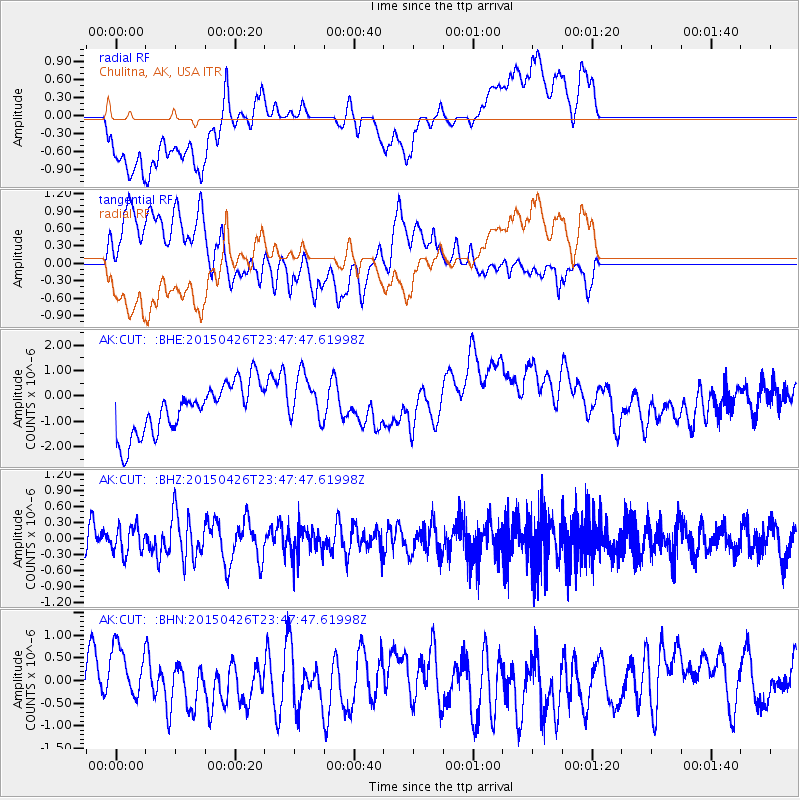
CUT Chulitna, AK, USA - Earthquake Result Viewer
*The percent match for this event was below the threshold and hence no stack was calculated.
| Earthquake location: |
Near Coast Of Northern Peru |
| Earthquake latitude/longitude: |
-8.3/-79.8 |
| Earthquake time(UTC): |
2015/04/26 (116) 23:35:29 GMT |
| Earthquake Depth: |
22 km |
| Earthquake Magnitude: |
5.6 MWW, 5.6 MWB, 5.7 MWC |
| Earthquake Catalog/Contributor: |
NEIC PDE/NEIC COMCAT |
|
| Network: |
AK Alaska Regional Network |
| Station: |
CUT Chulitna, AK, USA |
| Lat/Lon: |
62.41 N/150.26 W |
| Elevation: |
574 m |
|
| Distance: |
88.4 deg |
| Az: |
333.962 deg |
| Baz: |
111.103 deg |
| Ray Param: |
$rayparam |
*The percent match for this event was below the threshold and hence was not used in the summary stack. |
|
| Radial Match: |
37.814842 % |
| Radial Bump: |
400 |
| Transverse Match: |
54.42462 % |
| Transverse Bump: |
400 |
| SOD ConfigId: |
7422571 |
| Insert Time: |
2019-04-18 13:08:55.846 +0000 |
| GWidth: |
2.5 |
| Max Bumps: |
400 |
| Tol: |
0.001 |
|
Signal To Noise
| Channel | StoN | STA | LTA |
| AK:CUT: :BHZ:20150426T23:47:47.61998Z | 0.9272869 | 2.5345886E-7 | 2.733338E-7 |
| AK:CUT: :BHN:20150426T23:47:47.61998Z | 0.9484556 | 6.347616E-7 | 6.692581E-7 |
| AK:CUT: :BHE:20150426T23:47:47.61998Z | 0.99217516 | 9.3876287E-7 | 9.461665E-7 |
| Arrivals |
| Ps | |
| PpPs | |
| PsPs/PpSs | |


