You are here: Home > Network List > US - United States National Seismic Network Stations List
> Station DGMT Dagmar, Montana, USA > Earthquake Result Viewer
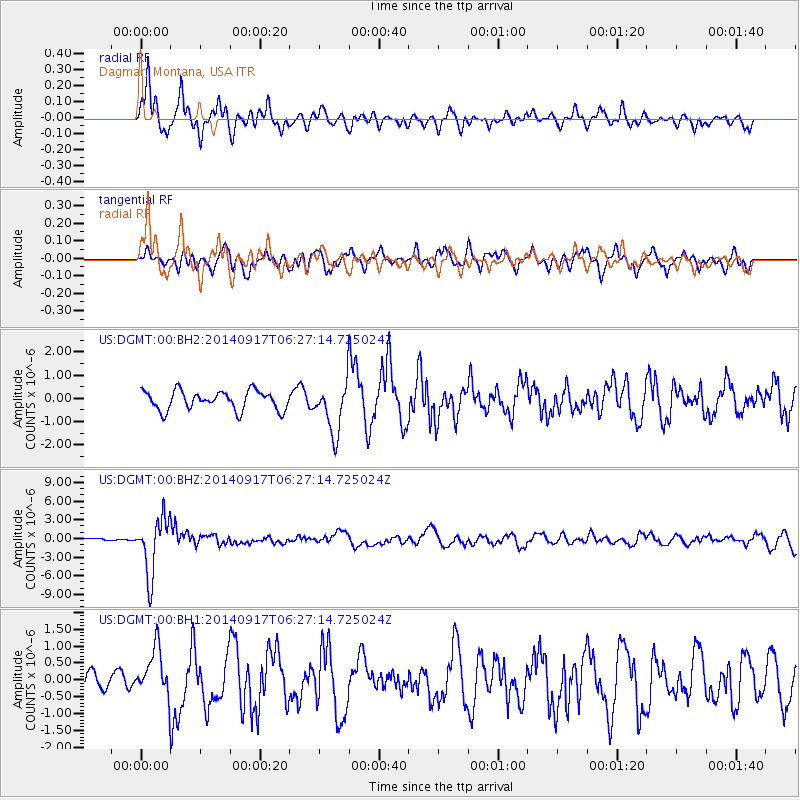
DGMT Dagmar, Montana, USA - Earthquake Result Viewer
*The percent match for this event was below the threshold and hence no stack was calculated.
| Earthquake location: |
Mariana Islands |
| Earthquake latitude/longitude: |
13.8/144.4 |
| Earthquake time(UTC): |
2014/09/17 (260) 06:14:46 GMT |
| Earthquake Depth: |
137 km |
| Earthquake Magnitude: |
6.7 MWC, 7.1 MI |
| Earthquake Catalog/Contributor: |
NEIC PDE/NEIC COMCAT |
|
| Network: |
US United States National Seismic Network |
| Station: |
DGMT Dagmar, Montana, USA |
| Lat/Lon: |
48.47 N/104.20 W |
| Elevation: |
0.0 m |
|
| Distance: |
93.4 deg |
| Az: |
38.367 deg |
| Baz: |
295.006 deg |
| Ray Param: |
$rayparam |
*The percent match for this event was below the threshold and hence was not used in the summary stack. |
|
| Radial Match: |
84.27951 % |
| Radial Bump: |
400 |
| Transverse Match: |
75.47739 % |
| Transverse Bump: |
400 |
| SOD ConfigId: |
795072 |
| Insert Time: |
2014-10-01 07:59:15.957 +0000 |
| GWidth: |
2.5 |
| Max Bumps: |
400 |
| Tol: |
0.001 |
|
Signal To Noise
| Channel | StoN | STA | LTA |
| US:DGMT:00:BHZ:20140917T06:27:14.725024Z | 29.92283 | 4.540513E-6 | 1.5174076E-7 |
| US:DGMT:00:BH1:20140917T06:27:14.725024Z | 1.8981037 | 7.2209144E-7 | 3.8042782E-7 |
| US:DGMT:00:BH2:20140917T06:27:14.725024Z | 2.6417296 | 1.0854391E-6 | 4.1088197E-7 |
| Arrivals |
| Ps | |
| PpPs | |
| PsPs/PpSs | |


