You are here: Home > Network List > IU - Global Seismograph Network (GSN - IRIS/USGS) Stations List
> Station AFI Afiamalu, Western Samoa > Earthquake Result Viewer
AFI Afiamalu, Western Samoa - Earthquake Result Viewer
| Earthquake location: |
Samar, Philippines |
| Earthquake latitude/longitude: |
12.6/125.2 |
| Earthquake time(UTC): |
1996/06/11 (163) 18:22:55 GMT |
| Earthquake Depth: |
33 km |
| Earthquake Magnitude: |
6.0 MB, 7.0 MS, 7.2 UNKNOWN, 7.1 MW |
| Earthquake Catalog/Contributor: |
WHDF/NEIC |
|
| Network: |
IU Global Seismograph Network (GSN - IRIS/USGS) |
| Station: |
AFI Afiamalu, Western Samoa |
| Lat/Lon: |
13.91 S/171.78 W |
| Elevation: |
706 m |
|
| Distance: |
67.8 deg |
| Az: |
110.785 deg |
| Baz: |
289.974 deg |
| Ray Param: |
0.05665576 |
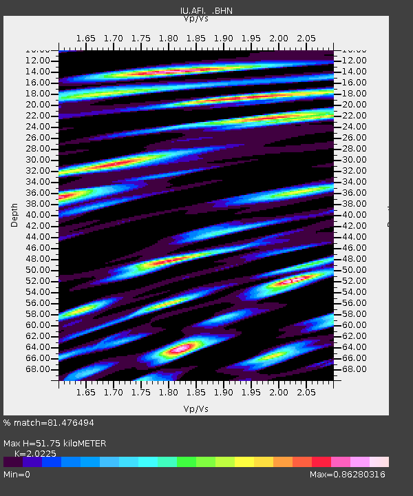
| Estimated Moho Depth: |
51.75 km |
| Estimated Crust Vp/Vs: |
2.02 |
| Assumed Crust Vp: |
4.24 km/s |
| Estimated Crust Vs: |
2.096 km/s |
| Estimated Crust Poisson's Ratio: |
0.34 |
|
| Radial Match: |
81.476494 % |
| Radial Bump: |
400 |
| Transverse Match: |
79.69757 % |
| Transverse Bump: |
400 |
| SOD ConfigId: |
6273 |
| Insert Time: |
2010-03-02 01:43:33.889 +0000 |
| GWidth: |
2.5 |
| Max Bumps: |
400 |
| Tol: |
0.001 |
|
Signal To Noise
| Channel | StoN | STA | LTA |
| IU:AFI: :BHN:19960611T18:33:19.614001Z | 1.4967571 | 1.256336E-6 | 8.393719E-7 |
| IU:AFI: :BHE:19960611T18:33:19.614001Z | 1.0766542 | 8.9370167E-7 | 8.300731E-7 |
| IU:AFI: :BHZ:19960611T18:33:19.614001Z | 2.5527549 | 1.1399152E-6 | 4.4654317E-7 |
| Arrivals |
| Ps | 13 SECOND |
| PpPs | 36 SECOND |
| PsPs/PpSs | 49 SECOND |


