You are here: Home > Network List > IU - Global Seismograph Network (GSN - IRIS/USGS) Stations List
> Station AFI Afiamalu, Western Samoa > Earthquake Result Viewer
AFI Afiamalu, Western Samoa - Earthquake Result Viewer
| Earthquake location: |
Flores Sea |
| Earthquake latitude/longitude: |
-7.1/122.6 |
| Earthquake time(UTC): |
1996/06/17 (169) 11:22:18 GMT |
| Earthquake Depth: |
587 km |
| Earthquake Magnitude: |
6.6 MB, 7.9 UNKNOWN, 7.8 MW |
| Earthquake Catalog/Contributor: |
WHDF/NEIC |
|
| Network: |
IU Global Seismograph Network (GSN - IRIS/USGS) |
| Station: |
AFI Afiamalu, Western Samoa |
| Lat/Lon: |
13.91 S/171.78 W |
| Elevation: |
706 m |
|
| Distance: |
64.7 deg |
| Az: |
101.974 deg |
| Baz: |
268.602 deg |
| Ray Param: |
0.056547787 |
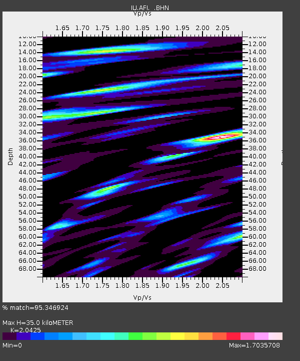
| Estimated Moho Depth: |
35.0 km |
| Estimated Crust Vp/Vs: |
2.04 |
| Assumed Crust Vp: |
4.24 km/s |
| Estimated Crust Vs: |
2.076 km/s |
| Estimated Crust Poisson's Ratio: |
0.34 |
|
| Radial Match: |
95.346924 % |
| Radial Bump: |
400 |
| Transverse Match: |
85.95853 % |
| Transverse Bump: |
400 |
| SOD ConfigId: |
6273 |
| Insert Time: |
2010-03-02 01:43:36.254 +0000 |
| GWidth: |
2.5 |
| Max Bumps: |
400 |
| Tol: |
0.001 |
|
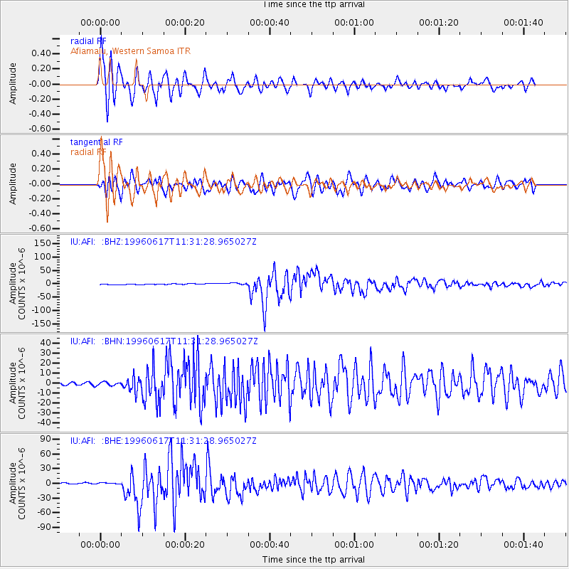
Signal To Noise
| Channel | StoN | STA | LTA |
| IU:AFI: :BHN:19960617T11:31:28.965027Z | 1.449293 | 1.6490035E-6 | 1.1377986E-6 |
| IU:AFI: :BHE:19960617T11:31:28.965027Z | 1.8596619 | 2.1216251E-6 | 1.140866E-6 |
| IU:AFI: :BHZ:19960617T11:31:28.965027Z | 2.3386357 | 3.489659E-6 | 1.4921773E-6 |
| Arrivals |
| Ps | 8.7 SECOND |
| PpPs | 25 SECOND |
| PsPs/PpSs | 33 SECOND |


