You are here: Home > Network List > IU - Global Seismograph Network (GSN - IRIS/USGS) Stations List
> Station AFI Afiamalu, Western Samoa > Earthquake Result Viewer
AFI Afiamalu, Western Samoa - Earthquake Result Viewer
| Earthquake location: |
Balleny Islands Region |
| Earthquake latitude/longitude: |
-62.9/149.5 |
| Earthquake time(UTC): |
1998/03/25 (084) 03:12:25 GMT |
| Earthquake Depth: |
10 km |
| Earthquake Magnitude: |
6.6 MB, 8.0 MS, 8.3 UNKNOWN, 8.1 MW |
| Earthquake Catalog/Contributor: |
WHDF/NEIC |
|
| Network: |
IU Global Seismograph Network (GSN - IRIS/USGS) |
| Station: |
AFI Afiamalu, Western Samoa |
| Lat/Lon: |
13.91 S/171.78 W |
| Elevation: |
706 m |
|
| Distance: |
56.0 deg |
| Az: |
47.101 deg |
| Baz: |
200.228 deg |
| Ray Param: |
0.06444841 |
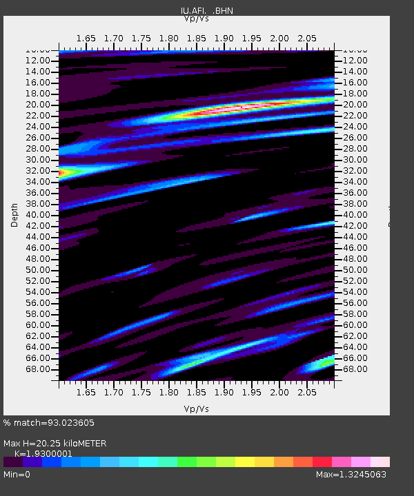
| Estimated Moho Depth: |
20.25 km |
| Estimated Crust Vp/Vs: |
1.93 |
| Assumed Crust Vp: |
4.24 km/s |
| Estimated Crust Vs: |
2.197 km/s |
| Estimated Crust Poisson's Ratio: |
0.32 |
|
| Radial Match: |
93.023605 % |
| Radial Bump: |
400 |
| Transverse Match: |
81.68282 % |
| Transverse Bump: |
400 |
| SOD ConfigId: |
6273 |
| Insert Time: |
2010-03-02 01:43:38.516 +0000 |
| GWidth: |
2.5 |
| Max Bumps: |
400 |
| Tol: |
0.001 |
|

Signal To Noise
| Channel | StoN | STA | LTA |
| IU:AFI: :BHN:19980325T03:21:32.364014Z | 0.7790666 | 1.3966475E-6 | 1.7927189E-6 |
| IU:AFI: :BHE:19980325T03:21:32.364014Z | 1.6411619 | 2.1029605E-6 | 1.2813852E-6 |
| IU:AFI: :BHZ:19980325T03:21:32.364014Z | 1.33776 | 2.2717009E-6 | 1.6981379E-6 |
| Arrivals |
| Ps | 4.5 SECOND |
| PpPs | 14 SECOND |
| PsPs/PpSs | 18 SECOND |


