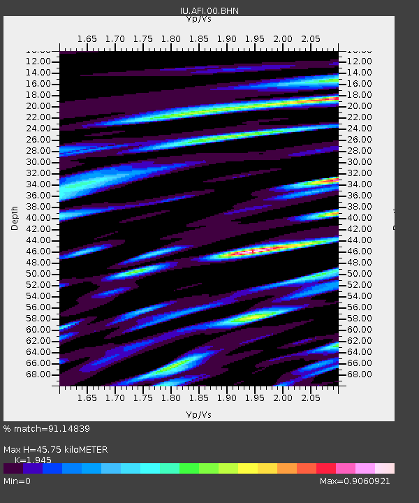
AFI Afiamalu, Western Samoa - Earthquake Result Viewer
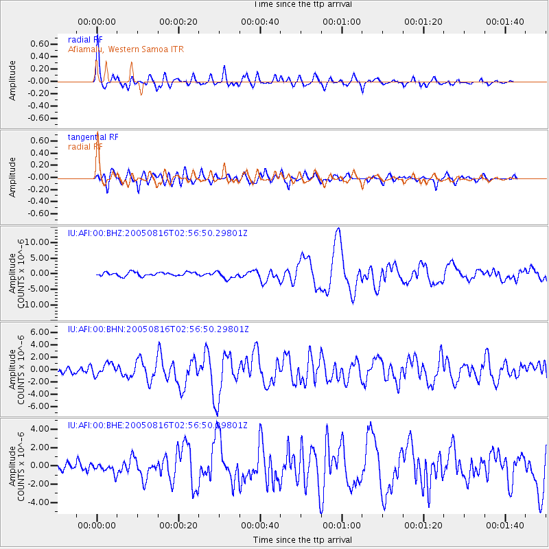
Earthquake location: Near East Coast Of Honshu, Japan
Earthquake latitude/longitude: 38.3/142.0
Earthquake time(UTC): 2005/08/16 (228) 02:46:28 GMT
Earthquake Depth: 36 km
Earthquake Magnitude: 6.5 MB, 6.8 MS, 7.2 MW, 7.1 MW
Earthquake Catalog/Contributor: WHDF/NEIC
Network: IU Global Seismograph Network (GSN - IRIS/USGS)
Station: AFI Afiamalu, Western Samoa
Lat/Lon: 13.91 S/171.78 W
Elevation: 706 m
Distance: 67.6 deg
Az: 130.703 deg
Baz: 322.088 deg
Ray Param: 0.056820884
Estimated Moho Depth: 45.75 km
Estimated Crust Vp/Vs: 1.95
Assumed Crust Vp: 4.24 km/s
Estimated Crust Vs: 2.18 km/s
Estimated Crust Poisson's Ratio: 0.32
Radial Match: 91.14839 %
Radial Bump: 400
Transverse Match: 80.67505 %
Transverse Bump: 400
SOD ConfigId: 2475
Insert Time: 2010-03-02 01:43:40.337 +0000
GWidth: 2.5
Max Bumps: 400
Tol: 0.001

Signal To Noise

ChannelStoNSTALTA
IU:AFI:00:BHN:20050816T02:56:50.29801Z1.36001889.879087E-77.263934E-7
IU:AFI:00:BHE:20050816T02:56:50.29801Z1.22637155.3840483E-74.3902264E-7
IU:AFI:00:BHZ:20050816T02:56:50.29801Z2.06451231.2177642E-65.898557E-7
Arrivals
Ps10 SECOND
PpPs31 SECOND
PsPs/PpSs42 SECOND