You are here: Home > Network List > UU - University of Utah Regional Network Stations List
> Station CVRU Castle Valley Ranch, Emery, UT, USA old TA-Q16A > Earthquake Result Viewer
CVRU Castle Valley Ranch, Emery, UT, USA old TA-Q16A - Earthquake Result Viewer
| Earthquake location: |
Mariana Islands |
| Earthquake latitude/longitude: |
13.8/144.4 |
| Earthquake time(UTC): |
2014/09/17 (260) 06:14:46 GMT |
| Earthquake Depth: |
137 km |
| Earthquake Magnitude: |
6.7 MWC, 7.1 MI |
| Earthquake Catalog/Contributor: |
NEIC PDE/NEIC COMCAT |
|
| Network: |
UU University of Utah Regional Network |
| Station: |
CVRU Castle Valley Ranch, Emery, UT, USA old TA-Q16A |
| Lat/Lon: |
38.92 N/111.17 W |
| Elevation: |
1912 m |
|
| Distance: |
92.4 deg |
| Az: |
49.124 deg |
| Baz: |
289.64 deg |
| Ray Param: |
0.041397233 |
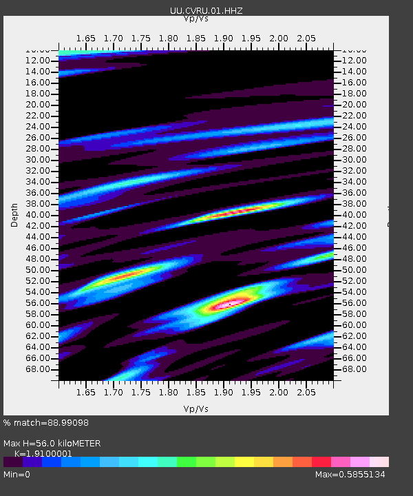
| Estimated Moho Depth: |
56.0 km |
| Estimated Crust Vp/Vs: |
1.91 |
| Assumed Crust Vp: |
6.207 km/s |
| Estimated Crust Vs: |
3.25 km/s |
| Estimated Crust Poisson's Ratio: |
0.31 |
|
| Radial Match: |
88.99098 % |
| Radial Bump: |
337 |
| Transverse Match: |
72.04555 % |
| Transverse Bump: |
330 |
| SOD ConfigId: |
795072 |
| Insert Time: |
2014-10-01 08:13:54.840 +0000 |
| GWidth: |
2.5 |
| Max Bumps: |
400 |
| Tol: |
0.001 |
|

Signal To Noise
| Channel | StoN | STA | LTA |
| UU:CVRU:01:HHZ:20140917T06:27:09.84801Z | 80.17431 | 2.1226137E-7 | 2.6474987E-9 |
| UU:CVRU:01:HHN:20140917T06:27:09.84801Z | 9.73113 | 2.922075E-8 | 3.0028118E-9 |
| UU:CVRU:01:HHE:20140917T06:27:09.84801Z | 23.700394 | 5.872722E-8 | 2.4779006E-9 |
| Arrivals |
| Ps | 8.4 SECOND |
| PpPs | 26 SECOND |
| PsPs/PpSs | 34 SECOND |


