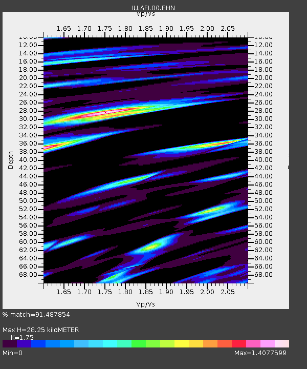
AFI Afiamalu, Western Samoa - Earthquake Result Viewer
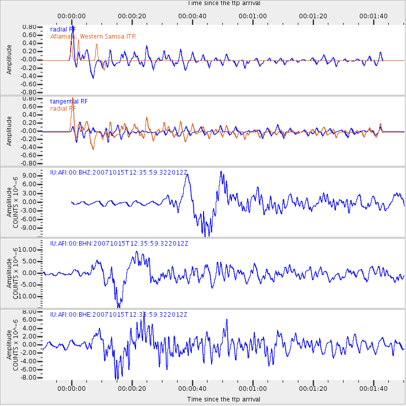
Earthquake location: South Island, New Zealand
Earthquake latitude/longitude: -44.8/167.6
Earthquake time(UTC): 2007/10/15 (288) 12:29:36 GMT
Earthquake Depth: 26 km
Earthquake Magnitude: 6.0 MB, 6.8 MS, 6.8 MW, 6.7 MW
Earthquake Catalog/Contributor: WHDF/NEIC
Network: IU Global Seismograph Network (GSN - IRIS/USGS)
Station: AFI Afiamalu, Western Samoa
Lat/Lon: 13.91 S/171.78 W
Elevation: 706 m
Distance: 35.4 deg
Az: 36.188 deg
Baz: 205.658 deg
Ray Param: 0.077187
Estimated Moho Depth: 28.25 km
Estimated Crust Vp/Vs: 1.75
Assumed Crust Vp: 4.24 km/s
Estimated Crust Vs: 2.423 km/s
Estimated Crust Poisson's Ratio: 0.26
Radial Match: 91.487854 %
Radial Bump: 400
Transverse Match: 70.794075 %
Transverse Bump: 400
SOD ConfigId: 2564
Insert Time: 2010-03-02 01:43:44.728 +0000
GWidth: 2.5
Max Bumps: 400
Tol: 0.001

Signal To Noise

ChannelStoNSTALTA
IU:AFI:00:BHN:20071015T12:35:59.322012Z2.6785749.632945E-73.5962958E-7
IU:AFI:00:BHE:20071015T12:35:59.322012Z0.7504736.482145E-78.637412E-7
IU:AFI:00:BHZ:20071015T12:35:59.322012Z2.4517751.2553443E-65.120145E-7
Arrivals
Ps5.2 SECOND
PpPs18 SECOND
PsPs/PpSs23 SECOND