You are here: Home > Network List > UU - University of Utah Regional Network Stations List
> Station RDMU Red Mountain, UT, USA > Earthquake Result Viewer
RDMU Red Mountain, UT, USA - Earthquake Result Viewer
| Earthquake location: |
Mariana Islands |
| Earthquake latitude/longitude: |
13.8/144.4 |
| Earthquake time(UTC): |
2014/09/17 (260) 06:14:46 GMT |
| Earthquake Depth: |
137 km |
| Earthquake Magnitude: |
6.7 MWC, 7.1 MI |
| Earthquake Catalog/Contributor: |
NEIC PDE/NEIC COMCAT |
|
| Network: |
UU University of Utah Regional Network |
| Station: |
RDMU Red Mountain, UT, USA |
| Lat/Lon: |
40.57 N/109.57 W |
| Elevation: |
2087 m |
|
| Distance: |
92.9 deg |
| Az: |
47.146 deg |
| Baz: |
290.752 deg |
| Ray Param: |
0.04128092 |
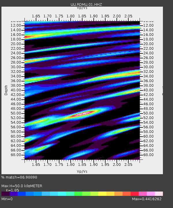
| Estimated Moho Depth: |
50.0 km |
| Estimated Crust Vp/Vs: |
1.85 |
| Assumed Crust Vp: |
6.207 km/s |
| Estimated Crust Vs: |
3.355 km/s |
| Estimated Crust Poisson's Ratio: |
0.29 |
|
| Radial Match: |
86.98898 % |
| Radial Bump: |
400 |
| Transverse Match: |
78.75357 % |
| Transverse Bump: |
400 |
| SOD ConfigId: |
795072 |
| Insert Time: |
2014-10-01 08:14:25.581 +0000 |
| GWidth: |
2.5 |
| Max Bumps: |
400 |
| Tol: |
0.001 |
|

Signal To Noise
| Channel | StoN | STA | LTA |
| UU:RDMU:01:HHZ:20140917T06:27:12.549976Z | 50.7683 | 2.0579064E-7 | 4.0535264E-9 |
| UU:RDMU:01:HHN:20140917T06:27:12.549976Z | 7.3108068 | 2.1101146E-8 | 2.8862952E-9 |
| UU:RDMU:01:HHE:20140917T06:27:12.549976Z | 12.352157 | 4.5671182E-8 | 3.6974257E-9 |
| Arrivals |
| Ps | 7.0 SECOND |
| PpPs | 23 SECOND |
| PsPs/PpSs | 30 SECOND |


