You are here: Home > Network List > IU - Global Seismograph Network (GSN - IRIS/USGS) Stations List
> Station AFI Afiamalu, Western Samoa > Earthquake Result Viewer
AFI Afiamalu, Western Samoa - Earthquake Result Viewer
| Earthquake location: |
Northern Molucca Sea |
| Earthquake latitude/longitude: |
2.9/127.5 |
| Earthquake time(UTC): |
2007/07/26 (207) 05:40:16 GMT |
| Earthquake Depth: |
25 km |
| Earthquake Magnitude: |
6.4 MB, 6.8 MS, 6.9 MW, 6.9 MW |
| Earthquake Catalog/Contributor: |
WHDF/NEIC |
|
| Network: |
IU Global Seismograph Network (GSN - IRIS/USGS) |
| Station: |
AFI Afiamalu, Western Samoa |
| Lat/Lon: |
13.91 S/171.78 W |
| Elevation: |
706 m |
|
| Distance: |
62.5 deg |
| Az: |
107.193 deg |
| Baz: |
280.713 deg |
| Ray Param: |
0.06015534 |
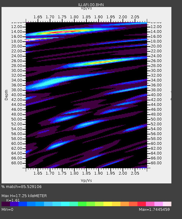
| Estimated Moho Depth: |
17.25 km |
| Estimated Crust Vp/Vs: |
1.61 |
| Assumed Crust Vp: |
4.24 km/s |
| Estimated Crust Vs: |
2.633 km/s |
| Estimated Crust Poisson's Ratio: |
0.19 |
|
| Radial Match: |
85.529106 % |
| Radial Bump: |
400 |
| Transverse Match: |
70.63561 % |
| Transverse Bump: |
400 |
| SOD ConfigId: |
2564 |
| Insert Time: |
2010-03-02 01:43:55.496 +0000 |
| GWidth: |
2.5 |
| Max Bumps: |
400 |
| Tol: |
0.001 |
|
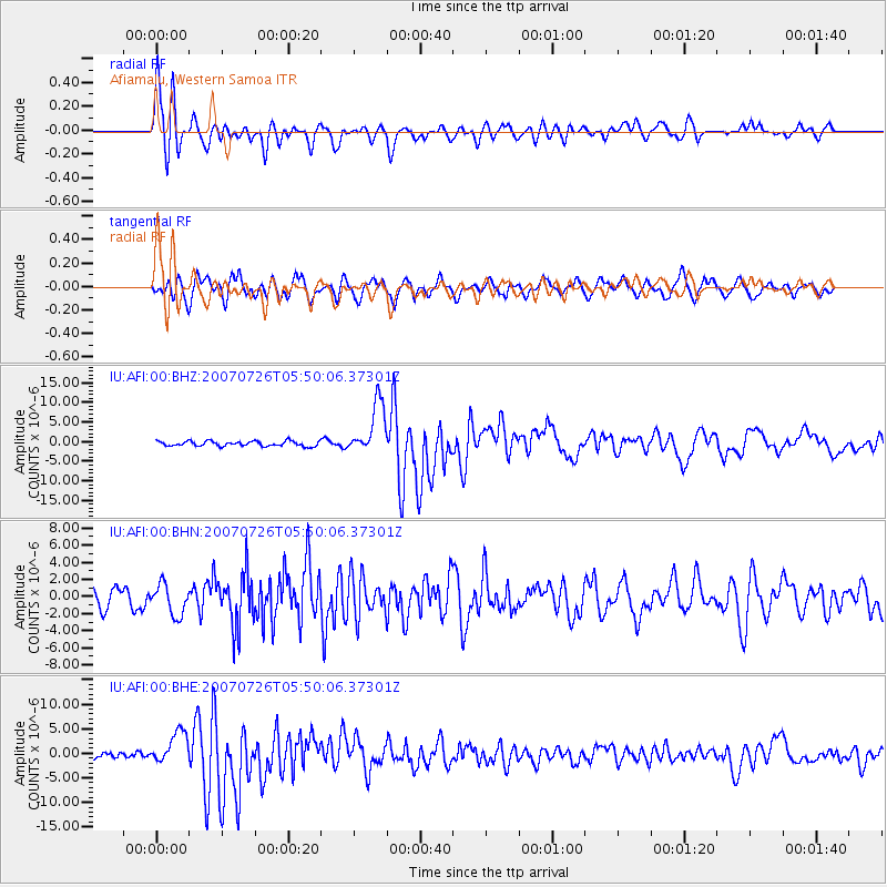
Signal To Noise
| Channel | StoN | STA | LTA |
| IU:AFI:00:BHN:20070726T05:50:06.37301Z | 1.4915297 | 1.8111681E-6 | 1.2143024E-6 |
| IU:AFI:00:BHE:20070726T05:50:06.37301Z | 2.6717904 | 3.3002555E-6 | 1.2352225E-6 |
| IU:AFI:00:BHZ:20070726T05:50:06.37301Z | 10.430279 | 6.624912E-6 | 6.3516154E-7 |
| Arrivals |
| Ps | 2.5 SECOND |
| PpPs | 10 SECOND |
| PsPs/PpSs | 13 SECOND |


