You are here: Home > Network List > IU - Global Seismograph Network (GSN - IRIS/USGS) Stations List
> Station AFI Afiamalu, Western Samoa > Earthquake Result Viewer
AFI Afiamalu, Western Samoa - Earthquake Result Viewer
| Earthquake location: |
Solomon Islands |
| Earthquake latitude/longitude: |
-8.5/157.0 |
| Earthquake time(UTC): |
2007/04/01 (091) 20:39:56 GMT |
| Earthquake Depth: |
10 km |
| Earthquake Magnitude: |
6.8 MB, 7.9 MS, 8.1 MW, 7.7 ME |
| Earthquake Catalog/Contributor: |
WHDF/NEIC |
|
| Network: |
IU Global Seismograph Network (GSN - IRIS/USGS) |
| Station: |
AFI Afiamalu, Western Samoa |
| Lat/Lon: |
13.91 S/171.78 W |
| Elevation: |
706 m |
|
| Distance: |
31.0 deg |
| Az: |
102.872 deg |
| Baz: |
276.709 deg |
| Ray Param: |
0.07917313 |
| Estimated Moho Depth: |
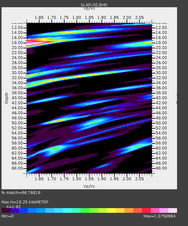
18.25 km |
| Estimated Crust Vp/Vs: |
1.62 |
| Assumed Crust Vp: |
4.24 km/s |
| Estimated Crust Vs: |
2.617 km/s |
| Estimated Crust Poisson's Ratio: |
0.19 |
|
| Radial Match: |
96.76819 % |
| Radial Bump: |
386 |
| Transverse Match: |
67.01391 % |
| Transverse Bump: |
400 |
| SOD ConfigId: |
2564 |
| Insert Time: |
2010-03-02 01:43:58.357 +0000 |
| GWidth: |
2.5 |
| Max Bumps: |
400 |
| Tol: |
0.001 |
|
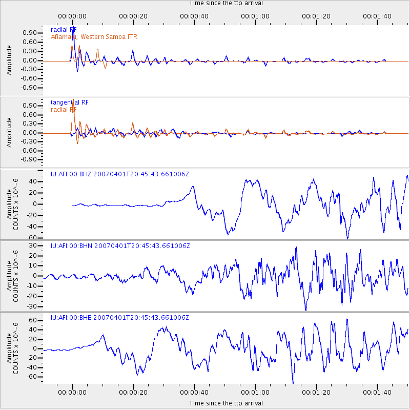
Signal To Noise
| Channel | StoN | STA | LTA |
| IU:AFI:00:BHN:20070401T20:45:43.661006Z | 0.59658206 | 1.2351728E-6 | 2.0704156E-6 |
| IU:AFI:00:BHE:20070401T20:45:43.661006Z | 3.492597 | 4.7844187E-6 | 1.3698743E-6 |
| IU:AFI:00:BHZ:20070401T20:45:43.661006Z | 5.7014394 | 6.08683E-6 | 1.0675953E-6 |
| Arrivals |
| Ps | 2.8 SECOND |
| PpPs | 11 SECOND |
| PsPs/PpSs | 14 SECOND |


