You are here: Home > Network List > UW - Pacific Northwest Regional Seismic Network Stations List
> Station SHUK Shuksan (Mt. Baker Ski Area), WA > Earthquake Result Viewer
SHUK Shuksan (Mt. Baker Ski Area), WA - Earthquake Result Viewer
| Earthquake location: |
Mariana Islands |
| Earthquake latitude/longitude: |
13.8/144.4 |
| Earthquake time(UTC): |
2014/09/17 (260) 06:14:46 GMT |
| Earthquake Depth: |
137 km |
| Earthquake Magnitude: |
6.7 MWC, 7.1 MI |
| Earthquake Catalog/Contributor: |
NEIC PDE/NEIC COMCAT |
|
| Network: |
UW Pacific Northwest Regional Seismic Network |
| Station: |
SHUK Shuksan (Mt. Baker Ski Area), WA |
| Lat/Lon: |
48.85 N/121.68 W |
| Elevation: |
1516 m |
|
| Distance: |
82.3 deg |
| Az: |
41.674 deg |
| Baz: |
281.998 deg |
| Ray Param: |
0.04664934 |
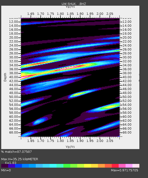
| Estimated Moho Depth: |
35.25 km |
| Estimated Crust Vp/Vs: |
1.83 |
| Assumed Crust Vp: |
6.566 km/s |
| Estimated Crust Vs: |
3.588 km/s |
| Estimated Crust Poisson's Ratio: |
0.29 |
|
| Radial Match: |
87.07587 % |
| Radial Bump: |
400 |
| Transverse Match: |
86.195335 % |
| Transverse Bump: |
400 |
| SOD ConfigId: |
795072 |
| Insert Time: |
2014-10-01 08:16:10.481 +0000 |
| GWidth: |
2.5 |
| Max Bumps: |
400 |
| Tol: |
0.001 |
|

Signal To Noise
| Channel | StoN | STA | LTA |
| UW:SHUK: :BHZ:20140917T06:26:21.559985Z | 55.41581 | 2.2075767E-5 | 3.9836587E-7 |
| UW:SHUK: :BHN:20140917T06:26:21.559985Z | 19.515762 | 7.3001625E-6 | 3.740649E-7 |
| UW:SHUK: :BHE:20140917T06:26:21.559985Z | 18.209236 | 7.822153E-6 | 4.295706E-7 |
| Arrivals |
| Ps | 4.6 SECOND |
| PpPs | 15 SECOND |
| PsPs/PpSs | 19 SECOND |


