You are here: Home > Network List > LD - Lamont-Doherty Cooperative Seismographic Network Stations List
> Station TUPA Temple University, Pennsylvania > Earthquake Result Viewer
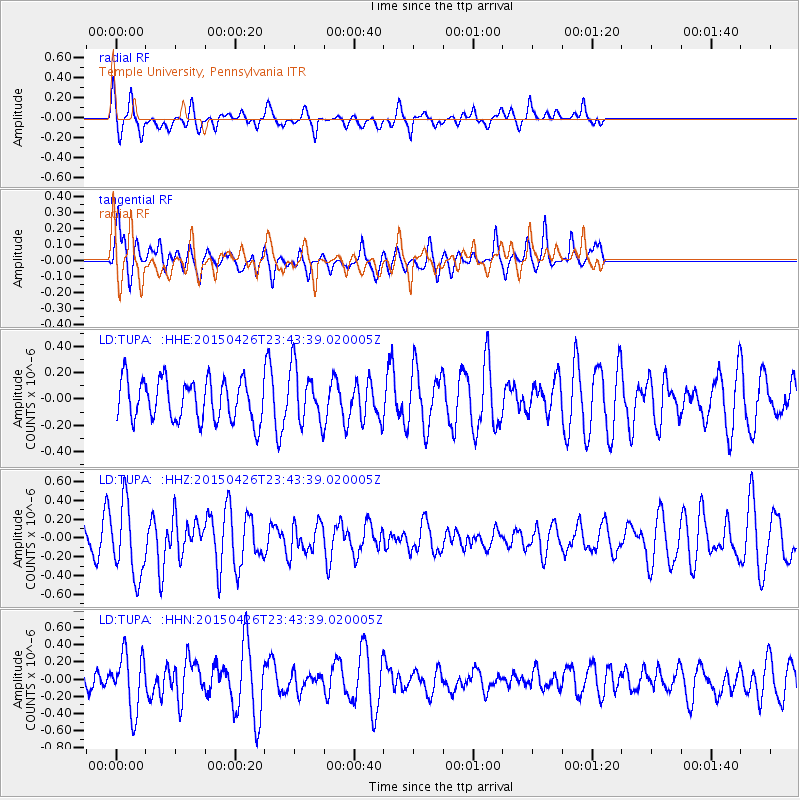
TUPA Temple University, Pennsylvania - Earthquake Result Viewer
*The percent match for this event was below the threshold and hence no stack was calculated.
| Earthquake location: |
Near Coast Of Northern Peru |
| Earthquake latitude/longitude: |
-8.3/-79.8 |
| Earthquake time(UTC): |
2015/04/26 (116) 23:35:29 GMT |
| Earthquake Depth: |
22 km |
| Earthquake Magnitude: |
5.6 MWW, 5.6 MWB, 5.7 MWC |
| Earthquake Catalog/Contributor: |
NEIC PDE/NEIC COMCAT |
|
| Network: |
LD Lamont-Doherty Cooperative Seismographic Network |
| Station: |
TUPA Temple University, Pennsylvania |
| Lat/Lon: |
40.17 N/75.19 W |
| Elevation: |
112 m |
|
| Distance: |
48.4 deg |
| Az: |
4.741 deg |
| Baz: |
186.127 deg |
| Ray Param: |
$rayparam |
*The percent match for this event was below the threshold and hence was not used in the summary stack. |
|
| Radial Match: |
66.35128 % |
| Radial Bump: |
354 |
| Transverse Match: |
52.640114 % |
| Transverse Bump: |
359 |
| SOD ConfigId: |
7422571 |
| Insert Time: |
2019-04-18 13:11:37.017 +0000 |
| GWidth: |
2.5 |
| Max Bumps: |
400 |
| Tol: |
0.001 |
|
Signal To Noise
| Channel | StoN | STA | LTA |
| LD:TUPA: :HHZ:20150426T23:43:39.020005Z | 2.6878467 | 3.8343617E-7 | 1.4265552E-7 |
| LD:TUPA: :HHN:20150426T23:43:39.020005Z | 1.8858265 | 3.315593E-7 | 1.7581644E-7 |
| LD:TUPA: :HHE:20150426T23:43:39.020005Z | 1.3134419 | 2.1132166E-7 | 1.6089152E-7 |
| Arrivals |
| Ps | |
| PpPs | |
| PsPs/PpSs | |


