You are here: Home > Network List > IU - Global Seismograph Network (GSN - IRIS/USGS) Stations List
> Station AFI Afiamalu, Samoa > Earthquake Result Viewer
AFI Afiamalu, Samoa - Earthquake Result Viewer
| Earthquake location: |
Banda Sea |
| Earthquake latitude/longitude: |
-7.1/123.4 |
| Earthquake time(UTC): |
2009/08/28 (240) 01:51:20 GMT |
| Earthquake Depth: |
642 km |
| Earthquake Magnitude: |
6.3 MB, 6.9 MW, 6.9 MW |
| Earthquake Catalog/Contributor: |
WHDF/NEIC |
|
| Network: |
IU Global Seismograph Network (GSN - IRIS/USGS) |
| Station: |
AFI Afiamalu, Samoa |
| Lat/Lon: |
13.91 S/171.78 W |
| Elevation: |
706 m |
|
| Distance: |
63.9 deg |
| Az: |
101.949 deg |
| Baz: |
268.784 deg |
| Ray Param: |
0.056774203 |
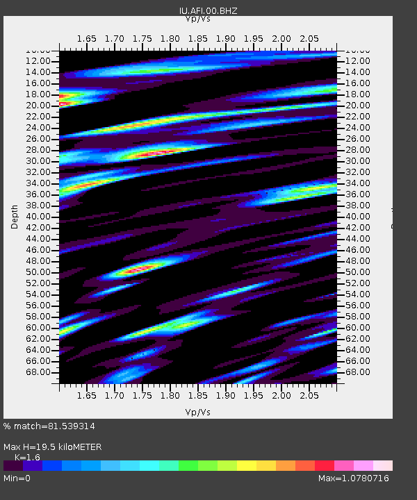
| Estimated Moho Depth: |
19.5 km |
| Estimated Crust Vp/Vs: |
1.60 |
| Assumed Crust Vp: |
4.24 km/s |
| Estimated Crust Vs: |
2.65 km/s |
| Estimated Crust Poisson's Ratio: |
0.18 |
|
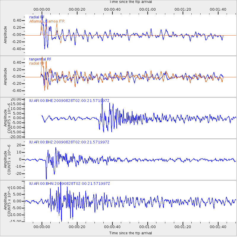
| Radial Match: |
81.539314 % |
| Radial Bump: |
400 |
| Transverse Match: |
75.9605 % |
| Transverse Bump: |
400 |
| SOD ConfigId: |
2622 |
| Insert Time: |
2010-03-02 01:44:04.638 +0000 |
| GWidth: |
2.5 |
| Max Bumps: |
400 |
| Tol: |
0.001 |
|
Signal To Noise
| Channel | StoN | STA | LTA |
| IU:AFI:00:BHZ:20090828T02:00:21.571997Z | 8.346512 | 7.741295E-6 | 9.2748866E-7 |
| IU:AFI:00:BHN:20090828T02:00:21.571997Z | 2.264645 | 2.3948237E-6 | 1.0574831E-6 |
| IU:AFI:00:BHE:20090828T02:00:21.571997Z | 4.5677958 | 6.0280267E-6 | 1.3196794E-6 |
| Arrivals |
| Ps | 2.8 SECOND |
| PpPs | 12 SECOND |
| PsPs/PpSs | 15 SECOND |


