You are here: Home > Network List > UW - Pacific Northwest Regional Seismic Network Stations List
> Station STOR Enumclaw, WA, USA > Earthquake Result Viewer
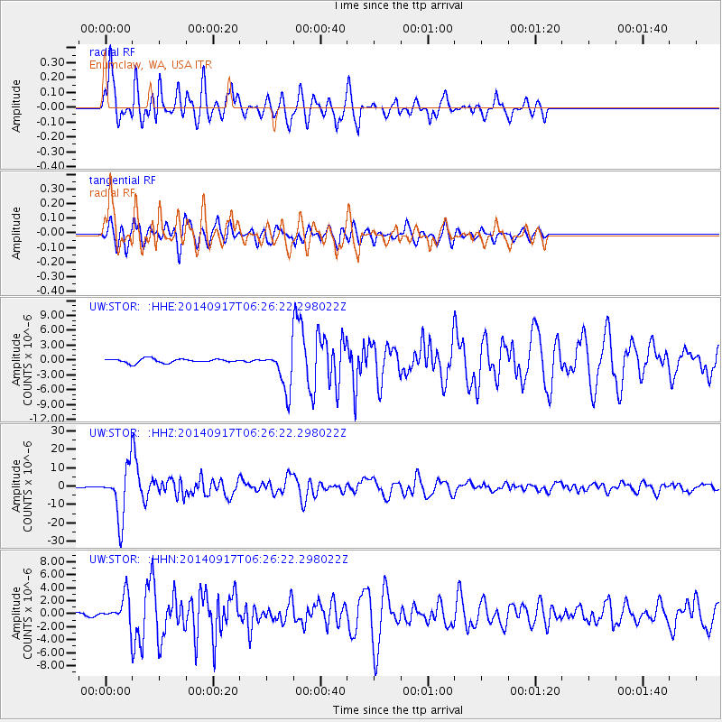
STOR Enumclaw, WA, USA - Earthquake Result Viewer
| Earthquake location: |
Mariana Islands |
| Earthquake latitude/longitude: |
13.8/144.4 |
| Earthquake time(UTC): |
2014/09/17 (260) 06:14:46 GMT |
| Earthquake Depth: |
137 km |
| Earthquake Magnitude: |
6.7 MWC, 7.1 MI |
| Earthquake Catalog/Contributor: |
NEIC PDE/NEIC COMCAT |
|
| Network: |
UW Pacific Northwest Regional Seismic Network |
| Station: |
STOR Enumclaw, WA, USA |
| Lat/Lon: |
47.19 N/121.99 W |
| Elevation: |
266 m |
|
| Distance: |
82.5 deg |
| Az: |
43.362 deg |
| Baz: |
281.99 deg |
| Ray Param: |
0.046551805 |
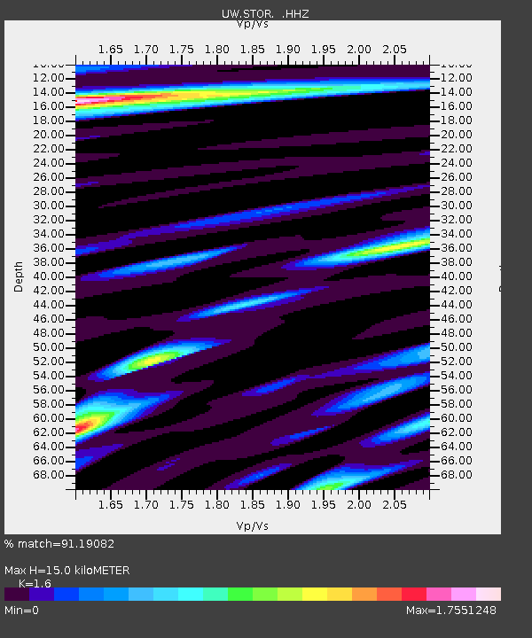
| Estimated Moho Depth: |
15.0 km |
| Estimated Crust Vp/Vs: |
1.60 |
| Assumed Crust Vp: |
6.597 km/s |
| Estimated Crust Vs: |
4.123 km/s |
| Estimated Crust Poisson's Ratio: |
0.18 |
|
| Radial Match: |
91.19082 % |
| Radial Bump: |
400 |
| Transverse Match: |
84.041916 % |
| Transverse Bump: |
400 |
| SOD ConfigId: |
795072 |
| Insert Time: |
2014-10-01 08:16:15.779 +0000 |
| GWidth: |
2.5 |
| Max Bumps: |
400 |
| Tol: |
0.001 |
|
Signal To Noise
| Channel | StoN | STA | LTA |
| UW:STOR: :HHZ:20140917T06:26:22.298022Z | 63.379097 | 1.3732114E-5 | 2.1666628E-7 |
| UW:STOR: :HHN:20140917T06:26:22.298022Z | 6.9862003 | 2.0999873E-6 | 3.0059076E-7 |
| UW:STOR: :HHE:20140917T06:26:22.298022Z | 9.9347515 | 4.077987E-6 | 4.10477E-7 |
| Arrivals |
| Ps | 1.4 SECOND |
| PpPs | 5.7 SECOND |
| PsPs/PpSs | 7.1 SECOND |


