You are here: Home > Network List > IU - Global Seismograph Network (GSN - IRIS/USGS) Stations List
> Station AFI Afiamalu, Samoa > Earthquake Result Viewer
AFI Afiamalu, Samoa - Earthquake Result Viewer
| Earthquake location: |
North Of Honduras |
| Earthquake latitude/longitude: |
16.7/-86.2 |
| Earthquake time(UTC): |
2009/05/28 (148) 08:24:45 GMT |
| Earthquake Depth: |
10 km |
| Earthquake Magnitude: |
6.7 MB, 7.2 MS, 7.3 MW, 7.3 MW |
| Earthquake Catalog/Contributor: |
WHDF/NEIC |
|
| Network: |
IU Global Seismograph Network (GSN - IRIS/USGS) |
| Station: |
AFI Afiamalu, Samoa |
| Lat/Lon: |
13.91 S/171.78 W |
| Elevation: |
706 m |
|
| Distance: |
89.8 deg |
| Az: |
255.495 deg |
| Baz: |
72.816 deg |
| Ray Param: |
0.041720923 |
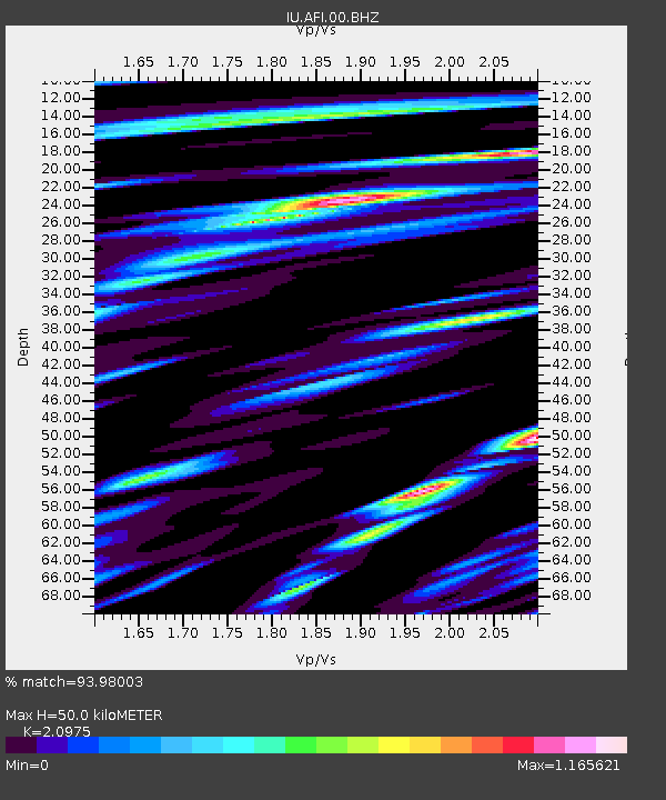
| Estimated Moho Depth: |
50.0 km |
| Estimated Crust Vp/Vs: |
2.10 |
| Assumed Crust Vp: |
4.24 km/s |
| Estimated Crust Vs: |
2.021 km/s |
| Estimated Crust Poisson's Ratio: |
0.35 |
|
| Radial Match: |
93.98003 % |
| Radial Bump: |
400 |
| Transverse Match: |
83.505974 % |
| Transverse Bump: |
400 |
| SOD ConfigId: |
2648 |
| Insert Time: |
2010-03-02 01:44:07.439 +0000 |
| GWidth: |
2.5 |
| Max Bumps: |
400 |
| Tol: |
0.001 |
|
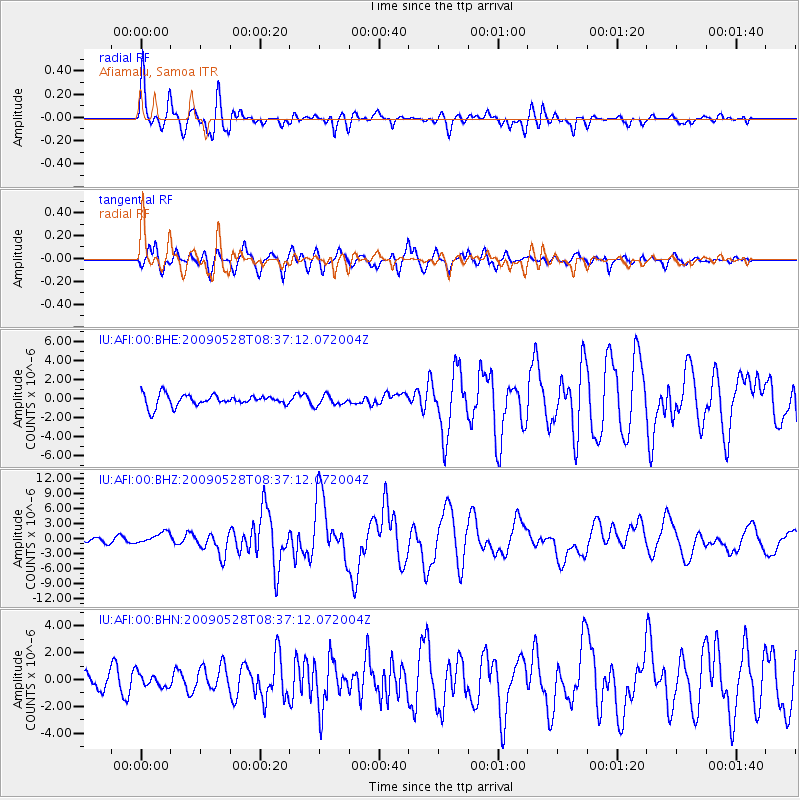
Signal To Noise
| Channel | StoN | STA | LTA |
| IU:AFI:00:BHZ:20090528T08:37:12.072004Z | 2.661681 | 1.096569E-6 | 4.1198365E-7 |
| IU:AFI:00:BHN:20090528T08:37:12.072004Z | 0.7654382 | 4.840647E-7 | 6.32402E-7 |
| IU:AFI:00:BHE:20090528T08:37:12.072004Z | 0.8623439 | 5.1639813E-7 | 5.988308E-7 |
| Arrivals |
| Ps | 13 SECOND |
| PpPs | 36 SECOND |
| PsPs/PpSs | 49 SECOND |


