You are here: Home > Network List > IU - Global Seismograph Network (GSN - IRIS/USGS) Stations List
> Station AFI Afiamalu, Western Samoa > Earthquake Result Viewer
AFI Afiamalu, Western Samoa - Earthquake Result Viewer
| Earthquake location: |
Banda Sea |
| Earthquake latitude/longitude: |
-6.9/128.9 |
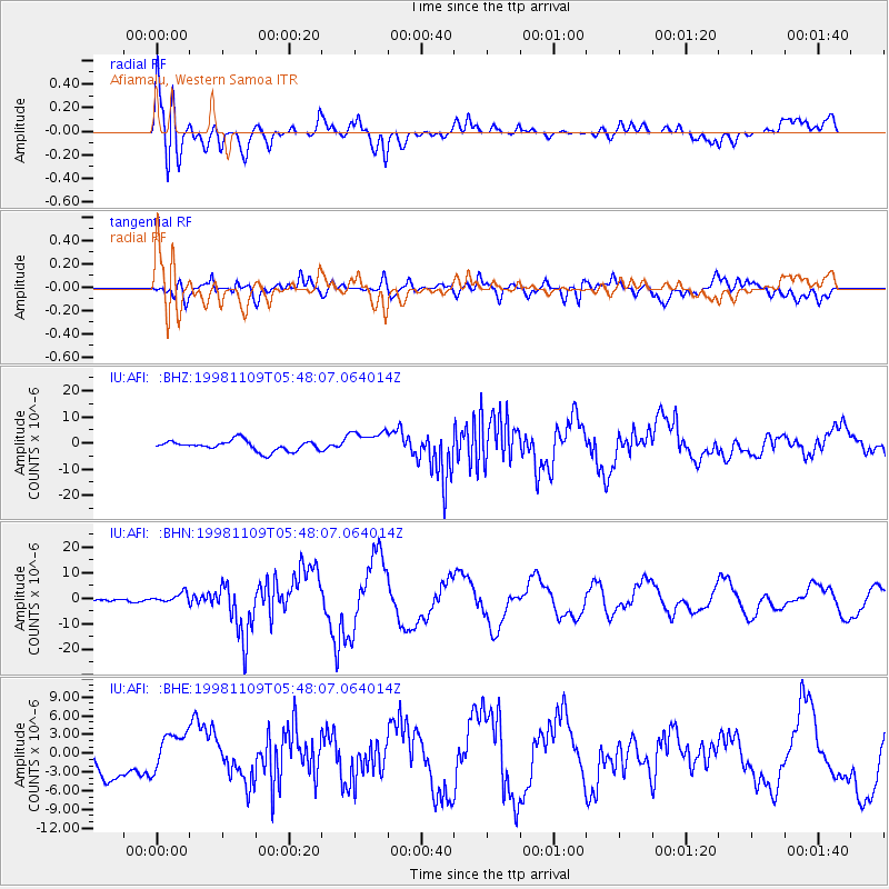
| Earthquake time(UTC): |
1998/11/09 (313) 05:38:44 GMT |
| Earthquake Depth: |
33 km |
| Earthquake Magnitude: |
6.4 MB, 7.0 MS, 7.3 UNKNOWN, 7.0 MW |
| Earthquake Catalog/Contributor: |
WHDF/NEIC |
|
| Network: |
IU Global Seismograph Network (GSN - IRIS/USGS) |
| Station: |
AFI Afiamalu, Western Samoa |
| Lat/Lon: |
13.91 S/171.78 W |
| Elevation: |
706 m |
|
| Distance: |
58.6 deg |
| Az: |
102.022 deg |
| Baz: |
270.331 deg |
| Ray Param: |
0.062686644 |
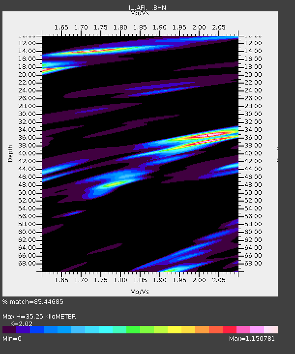
| Estimated Moho Depth: |
35.25 km |
| Estimated Crust Vp/Vs: |
2.02 |
| Assumed Crust Vp: |
4.24 km/s |
| Estimated Crust Vs: |
2.099 km/s |
| Estimated Crust Poisson's Ratio: |
0.34 |
|
| Radial Match: |
85.44685 % |
| Radial Bump: |
400 |
| Transverse Match: |
75.429634 % |
| Transverse Bump: |
400 |
| SOD ConfigId: |
4480 |
| Insert Time: |
2010-03-02 01:44:09.996 +0000 |
| GWidth: |
2.5 |
| Max Bumps: |
400 |
| Tol: |
0.001 |
|
Signal To Noise
| Channel | StoN | STA | LTA |
| IU:AFI: :BHN:19981109T05:48:07.064014Z | 2.0505717 | 1.8675901E-6 | 9.107656E-7 |
| IU:AFI: :BHE:19981109T05:48:07.064014Z | 1.4732785 | 3.020287E-6 | 2.050045E-6 |
| IU:AFI: :BHZ:19981109T05:48:07.064014Z | 2.3242397 | 4.549195E-6 | 1.957283E-6 |
| Arrivals |
| Ps | 8.6 SECOND |
| PpPs | 25 SECOND |
| PsPs/PpSs | 33 SECOND |


