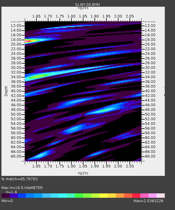
AFI Afiamalu, Western Samoa - Earthquake Result Viewer
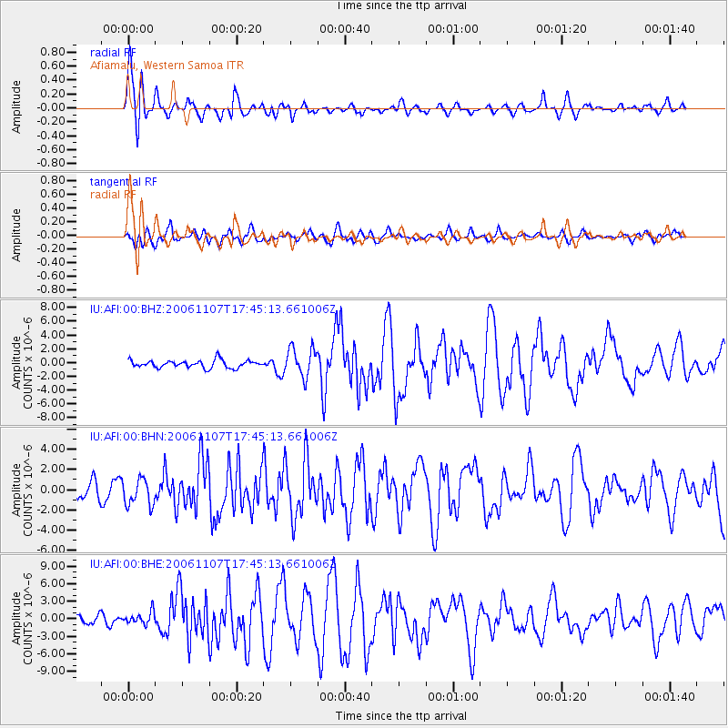
Earthquake location: New Britain Region, P.N.G.
Earthquake latitude/longitude: -6.5/151.2
Earthquake time(UTC): 2006/11/07 (311) 17:38:33 GMT
Earthquake Depth: 10 km
Earthquake Magnitude: 6.2 MB, 6.3 MS, 6.5 MW, 6.4 MW
Earthquake Catalog/Contributor: WHDF/NEIC
Network: IU Global Seismograph Network (GSN - IRIS/USGS)
Station: AFI Afiamalu, Western Samoa
Lat/Lon: 13.91 S/171.78 W
Elevation: 706 m
Distance: 37.1 deg
Az: 104.426 deg
Baz: 277.671 deg
Ray Param: 0.07629661
Estimated Moho Depth: 18.5 km
Estimated Crust Vp/Vs: 1.60
Assumed Crust Vp: 4.24 km/s
Estimated Crust Vs: 2.65 km/s
Estimated Crust Poisson's Ratio: 0.18
Radial Match: 85.79783 %
Radial Bump: 400
Transverse Match: 61.870335 %
Transverse Bump: 400
SOD ConfigId: 2564
Insert Time: 2010-03-02 01:44:12.336 +0000
GWidth: 2.5
Max Bumps: 400
Tol: 0.001

Signal To Noise

ChannelStoNSTALTA
IU:AFI:00:BHN:20061107T17:45:13.661006Z1.37759861.3050186E-69.473141E-7
IU:AFI:00:BHE:20061107T17:45:13.661006Z1.09030371.0570999E-69.695462E-7
IU:AFI:00:BHZ:20061107T17:45:13.661006Z3.83229332.1241237E-65.542696E-7
Arrivals
Ps2.7 SECOND
PpPs11 SECOND
PsPs/PpSs14 SECOND