You are here: Home > Network List > YN10 - San Jacinto Fault Zone Stations List
> Station JFN1 JFN1 > Earthquake Result Viewer
JFN1 JFN1 - Earthquake Result Viewer
| Earthquake location: |
Mariana Islands |
| Earthquake latitude/longitude: |
13.8/144.4 |
| Earthquake time(UTC): |
2014/09/17 (260) 06:14:46 GMT |
| Earthquake Depth: |
137 km |
| Earthquake Magnitude: |
6.7 MWC, 7.1 MI |
| Earthquake Catalog/Contributor: |
NEIC PDE/NEIC COMCAT |
|
| Network: |
YN San Jacinto Fault Zone |
| Station: |
JFN1 JFN1 |
| Lat/Lon: |
33.42 N/116.40 W |
| Elevation: |
645 m |
|
| Distance: |
90.0 deg |
| Az: |
55.645 deg |
| Baz: |
286.426 deg |
| Ray Param: |
0.041674744 |
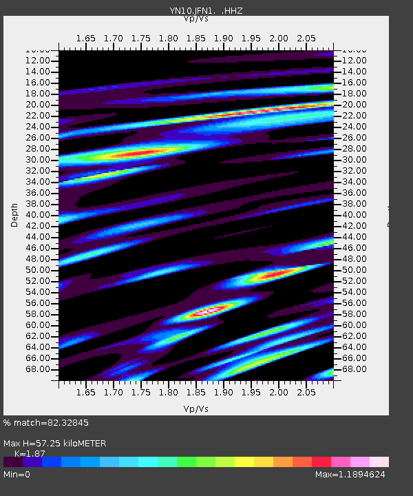
| Estimated Moho Depth: |
57.25 km |
| Estimated Crust Vp/Vs: |
1.87 |
| Assumed Crust Vp: |
6.264 km/s |
| Estimated Crust Vs: |
3.35 km/s |
| Estimated Crust Poisson's Ratio: |
0.30 |
|
| Radial Match: |
82.32845 % |
| Radial Bump: |
400 |
| Transverse Match: |
76.34484 % |
| Transverse Bump: |
400 |
| SOD ConfigId: |
795072 |
| Insert Time: |
2014-10-01 08:17:38.901 +0000 |
| GWidth: |
2.5 |
| Max Bumps: |
400 |
| Tol: |
0.001 |
|

Signal To Noise
| Channel | StoN | STA | LTA |
| YN:JFN1: :HHZ:20140917T06:26:59.083972Z | 32.34047 | 7.5517855E-6 | 2.3350884E-7 |
| YN:JFN1: :HHN:20140917T06:26:59.083972Z | 2.6570725 | 6.4432965E-7 | 2.4249607E-7 |
| YN:JFN1: :HHE:20140917T06:26:59.083972Z | 7.825752 | 2.5083955E-6 | 3.2053094E-7 |
| Arrivals |
| Ps | 8.1 SECOND |
| PpPs | 26 SECOND |
| PsPs/PpSs | 34 SECOND |


