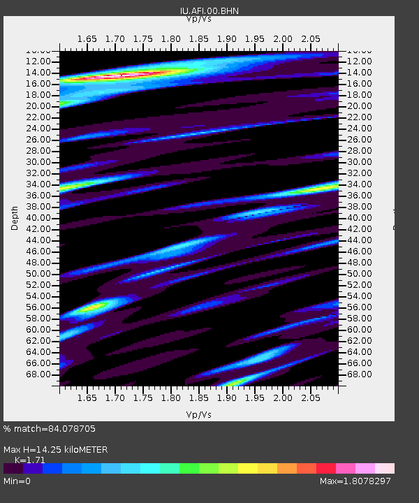
AFI Afiamalu, Western Samoa - Earthquake Result Viewer
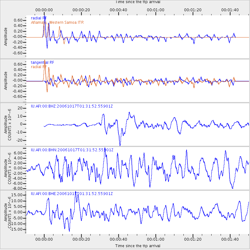
Earthquake location: New Britain Region, P.N.G.
Earthquake latitude/longitude: -5.9/151.0
Earthquake time(UTC): 2006/10/17 (290) 01:25:12 GMT
Earthquake Depth: 32 km
Earthquake Magnitude: 6.4 MB, 6.9 MS, 6.7 MW, 6.6 MW
Earthquake Catalog/Contributor: WHDF/NEIC
Network: IU Global Seismograph Network (GSN - IRIS/USGS)
Station: AFI Afiamalu, Western Samoa
Lat/Lon: 13.91 S/171.78 W
Elevation: 706 m
Distance: 37.5 deg
Az: 105.135 deg
Baz: 278.534 deg
Ray Param: 0.07604381
Estimated Moho Depth: 14.25 km
Estimated Crust Vp/Vs: 1.71
Assumed Crust Vp: 4.24 km/s
Estimated Crust Vs: 2.479 km/s
Estimated Crust Poisson's Ratio: 0.24
Radial Match: 84.078705 %
Radial Bump: 400
Transverse Match: 73.10535 %
Transverse Bump: 400
SOD ConfigId: 2564
Insert Time: 2010-03-02 01:44:16.389 +0000
GWidth: 2.5
Max Bumps: 400
Tol: 0.001

Signal To Noise

ChannelStoNSTALTA
IU:AFI:00:BHN:20061017T01:31:52.55901Z1.08094751.4479031E-61.3394758E-6
IU:AFI:00:BHE:20061017T01:31:52.55901Z4.7944716.6366074E-61.384221E-6
IU:AFI:00:BHZ:20061017T01:31:52.55901Z7.8835497.169123E-69.093776E-7
Arrivals
Ps2.5 SECOND
PpPs8.8 SECOND
PsPs/PpSs11 SECOND