You are here: Home > Network List > IU - Global Seismograph Network (GSN - IRIS/USGS) Stations List
> Station AFI Afiamalu, Western Samoa > Earthquake Result Viewer
AFI Afiamalu, Western Samoa - Earthquake Result Viewer
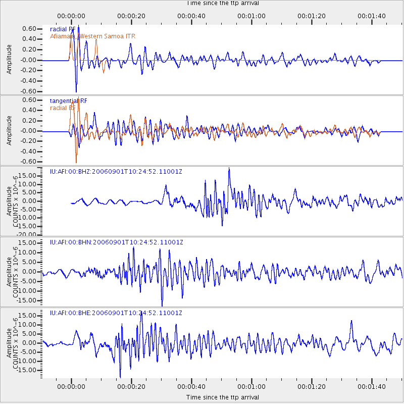
| Earthquake location: |
Solomon Islands |
| Earthquake latitude/longitude: |
-6.8/155.5 |
| Earthquake time(UTC): |
2006/09/01 (244) 10:18:51 GMT |
| Earthquake Depth: |
38 km |
| Earthquake Magnitude: |
6.3 MB, 6.7 MS, 6.8 MW, 6.7 MW |
| Earthquake Catalog/Contributor: |
WHDF/NEIC |
|
| Network: |
IU Global Seismograph Network (GSN - IRIS/USGS) |
| Station: |
AFI Afiamalu, Western Samoa |
| Lat/Lon: |
13.91 S/171.78 W |
| Elevation: |
706 m |
|
| Distance: |
32.9 deg |
| Az: |
105.112 deg |
| Baz: |
279.112 deg |
| Ray Param: |
0.07837547 |
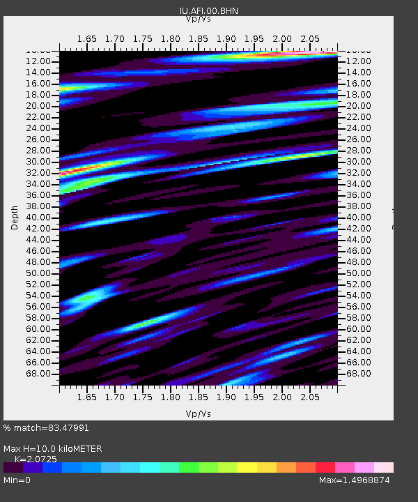
| Estimated Moho Depth: |
10.0 km |
| Estimated Crust Vp/Vs: |
2.07 |
| Assumed Crust Vp: |
4.24 km/s |
| Estimated Crust Vs: |
2.046 km/s |
| Estimated Crust Poisson's Ratio: |
0.35 |
|
| Radial Match: |
83.47991 % |
| Radial Bump: |
400 |
| Transverse Match: |
67.517166 % |
| Transverse Bump: |
400 |
| SOD ConfigId: |
2564 |
| Insert Time: |
2010-03-02 01:44:19.457 +0000 |
| GWidth: |
2.5 |
| Max Bumps: |
400 |
| Tol: |
0.001 |
|
Signal To Noise
| Channel | StoN | STA | LTA |
| IU:AFI:00:BHN:20060901T10:24:52.11001Z | 1.2078121 | 1.1934211E-6 | 9.88085E-7 |
| IU:AFI:00:BHE:20060901T10:24:52.11001Z | 3.805586 | 3.048703E-6 | 8.011126E-7 |
| IU:AFI:00:BHZ:20060901T10:24:52.11001Z | 3.770027 | 3.8989847E-6 | 1.0342061E-6 |
| Arrivals |
| Ps | 2.6 SECOND |
| PpPs | 7.0 SECOND |
| PsPs/PpSs | 9.6 SECOND |


