You are here: Home > Network List > IU - Global Seismograph Network (GSN - IRIS/USGS) Stations List
> Station AFI Afiamalu, Western Samoa > Earthquake Result Viewer
AFI Afiamalu, Western Samoa - Earthquake Result Viewer
| Earthquake location: |
Banda Sea |
| Earthquake latitude/longitude: |
-5.5/128.1 |
| Earthquake time(UTC): |
2006/01/27 (027) 16:58:53 GMT |
| Earthquake Depth: |
397 km |
| Earthquake Magnitude: |
7.0 MB, 7.6 MW, 7.5 MW |
| Earthquake Catalog/Contributor: |
WHDF/NEIC |
|
| Network: |
IU Global Seismograph Network (GSN - IRIS/USGS) |
| Station: |
AFI Afiamalu, Western Samoa |
| Lat/Lon: |
13.91 S/171.78 W |
| Elevation: |
706 m |
|
| Distance: |
59.7 deg |
| Az: |
102.844 deg |
| Baz: |
271.763 deg |
| Ray Param: |
0.06059328 |
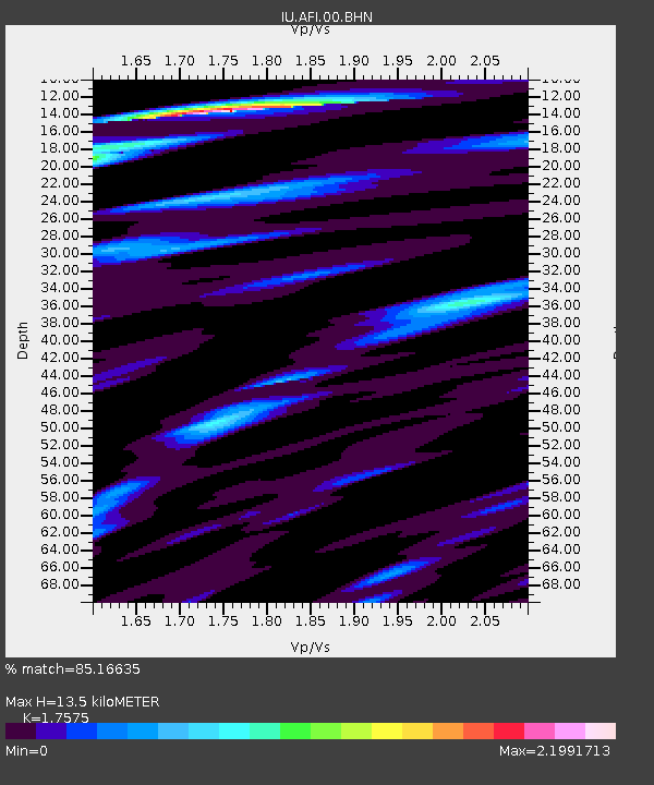
| Estimated Moho Depth: |
13.5 km |
| Estimated Crust Vp/Vs: |
1.76 |
| Assumed Crust Vp: |
4.24 km/s |
| Estimated Crust Vs: |
2.412 km/s |
| Estimated Crust Poisson's Ratio: |
0.26 |
|
| Radial Match: |
85.16635 % |
| Radial Bump: |
369 |
| Transverse Match: |
60.370457 % |
| Transverse Bump: |
400 |
| SOD ConfigId: |
4977 |
| Insert Time: |
2010-03-02 01:44:23.353 +0000 |
| GWidth: |
2.5 |
| Max Bumps: |
400 |
| Tol: |
0.001 |
|
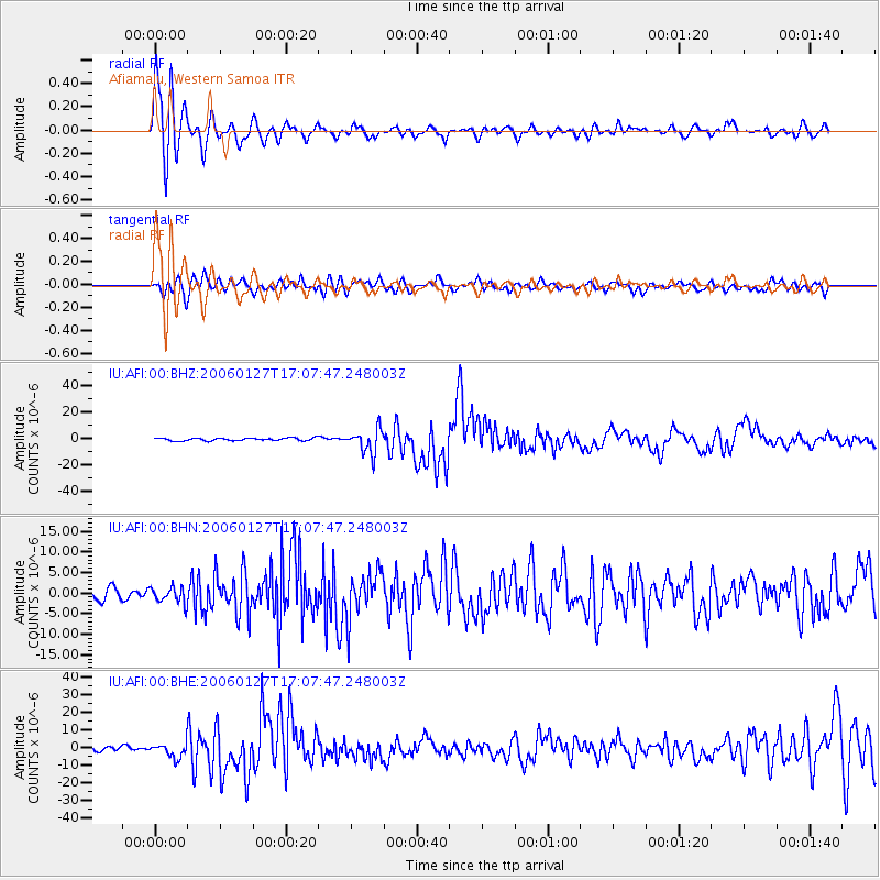
Signal To Noise
| Channel | StoN | STA | LTA |
| IU:AFI:00:BHN:20060127T17:07:47.248003Z | 1.4253253 | 1.9532167E-6 | 1.3703656E-6 |
| IU:AFI:00:BHE:20060127T17:07:47.248003Z | 3.1103961 | 4.0130244E-6 | 1.2901972E-6 |
| IU:AFI:00:BHZ:20060127T17:07:47.248003Z | 9.126146 | 9.110007E-6 | 9.982316E-7 |
| Arrivals |
| Ps | 2.5 SECOND |
| PpPs | 8.6 SECOND |
| PsPs/PpSs | 11 SECOND |


