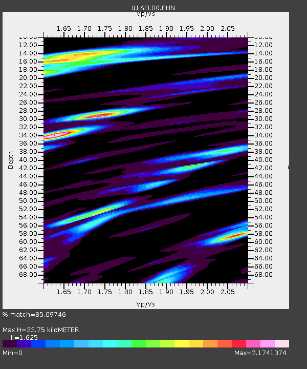
AFI Afiamalu, Western Samoa - Earthquake Result Viewer
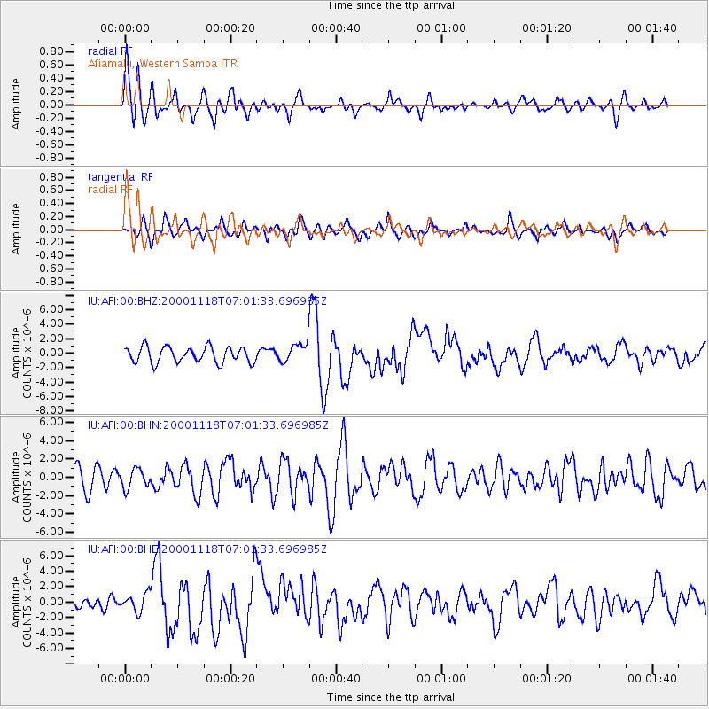
Earthquake location: New Britain Region, P.N.G.
Earthquake latitude/longitude: -5.2/151.8
Earthquake time(UTC): 2000/11/18 (323) 06:54:58 GMT
Earthquake Depth: 33 km
Earthquake Magnitude: 6.2 MB, 6.6 MS, 6.8 MW, 6.8 MW
Earthquake Catalog/Contributor: WHDF/NEIC
Network: IU Global Seismograph Network (GSN - IRIS/USGS)
Station: AFI Afiamalu, Western Samoa
Lat/Lon: 13.91 S/171.78 W
Elevation: 706 m
Distance: 36.9 deg
Az: 106.161 deg
Baz: 279.917 deg
Ray Param: 0.07635765
Estimated Moho Depth: 33.75 km
Estimated Crust Vp/Vs: 1.62
Assumed Crust Vp: 4.24 km/s
Estimated Crust Vs: 2.609 km/s
Estimated Crust Poisson's Ratio: 0.20
Radial Match: 85.09746 %
Radial Bump: 400
Transverse Match: 77.5574 %
Transverse Bump: 400
SOD ConfigId: 3744
Insert Time: 2010-03-02 01:44:24.893 +0000
GWidth: 2.5
Max Bumps: 400
Tol: 0.001

Signal To Noise

ChannelStoNSTALTA
IU:AFI:00:BHN:20001118T07:01:33.696985Z0.884253861.0408455E-61.1770891E-6
IU:AFI:00:BHE:20001118T07:01:33.696985Z1.41759981.1905548E-68.398385E-7
IU:AFI:00:BHZ:20001118T07:01:33.696985Z1.25835781.3557138E-61.0773676E-6
Arrivals
Ps5.1 SECOND
PpPs20 SECOND
PsPs/PpSs25 SECOND