You are here: Home > Network List > TD - TransAlta Monitoring Network Stations List
> Station TD013 Z > Earthquake Result Viewer
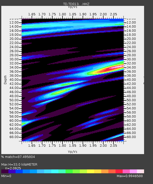
TD013 Z - Earthquake Result Viewer
| Earthquake location: |
Mariana Islands |
| Earthquake latitude/longitude: |
13.8/144.4 |
| Earthquake time(UTC): |
2014/09/17 (260) 06:14:46 GMT |
| Earthquake Depth: |
137 km |
| Earthquake Magnitude: |
6.7 MWC, 7.1 MI |
| Earthquake Catalog/Contributor: |
NEIC PDE/NEIC COMCAT |
|
| Network: |
TD TransAlta Monitoring Network |
| Station: |
TD013 Z |
| Lat/Lon: |
52.52 N/115.02 W |
| Elevation: |
975 m |
|
| Distance: |
85.5 deg |
| Az: |
37.052 deg |
| Baz: |
286.647 deg |
| Ray Param: |
0.04439748 |
| Estimated Moho Depth: |
33.0 km |
| Estimated Crust Vp/Vs: |
2.09 |
| Assumed Crust Vp: |
6.426 km/s |
| Estimated Crust Vs: |
3.071 km/s |
| Estimated Crust Poisson's Ratio: |
0.35 |
|
| Radial Match: |
87.495804 % |
| Radial Bump: |
400 |
| Transverse Match: |
67.5573 % |
| Transverse Bump: |
400 |
| SOD ConfigId: |
795072 |
| Insert Time: |
2014-10-01 08:22:24.096 +0000 |
| GWidth: |
2.5 |
| Max Bumps: |
400 |
| Tol: |
0.001 |
|

Signal To Noise
| Channel | StoN | STA | LTA |
| TD:TD013: :HHZ:20140917T06:26:37.71001Z | 51.93058 | 1.2427653E-5 | 2.393128E-7 |
| TD:TD013: :HH1:20140917T06:26:37.71001Z | 5.023721 | 1.1921311E-6 | 2.3730041E-7 |
| TD:TD013: :HH2:20140917T06:26:37.71001Z | 10.51075 | 2.616456E-6 | 2.4893143E-7 |
| Arrivals |
| Ps | 5.7 SECOND |
| PpPs | 16 SECOND |
| PsPs/PpSs | 21 SECOND |


