AFI Afiamalu, Western Samoa - Earthquake Result Viewer
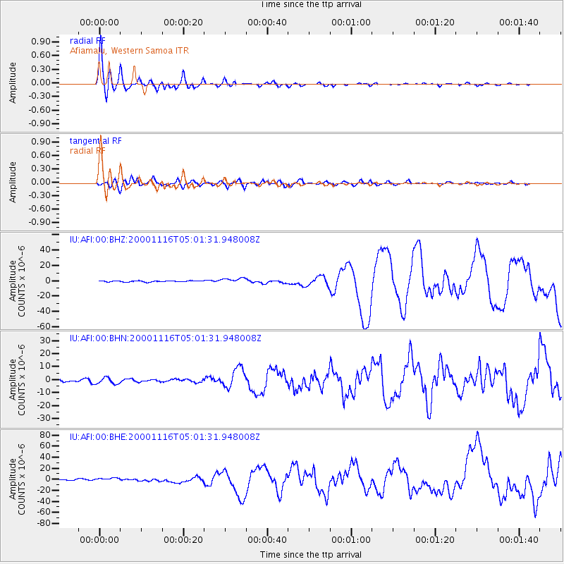
Earthquake location: New Ireland Region, P.N.G.
Earthquake latitude/longitude: -4.0/152.2
Earthquake time(UTC): 2000/11/16 (321) 04:54:56 GMT
Earthquake Depth: 33 km
Earthquake Magnitude: 6.0 MB, 8.2 MS, 8.0 MW, 8.0 ME
Earthquake Catalog/Contributor: WHDF/NEIC
Network: IU Global Seismograph Network (GSN - IRIS/USGS)
Station: AFI Afiamalu, Western Samoa
Lat/Lon: 13.91 S/171.78 W
Elevation: 706 m
Distance: 36.9 deg
Az: 107.862 deg
Baz: 282.085 deg
Ray Param: 0.07636673
Estimated Moho Depth: 15.0 km
Estimated Crust Vp/Vs: 1.67
Assumed Crust Vp: 4.24 km/s
Estimated Crust Vs: 2.539 km/s
Estimated Crust Poisson's Ratio: 0.22
Radial Match: 96.702736 %
Radial Bump: 400
Transverse Match: 89.12767 %
Transverse Bump: 400
SOD ConfigId: 3744
Insert Time: 2010-03-02 01:44:32.094 +0000
GWidth: 2.5
Max Bumps: 400
Tol: 0.001

Signal To Noise

ChannelStoNSTALTA
IU:AFI:00:BHN:20001116T05:01:31.948008Z2.8055332.3788416E-68.4791077E-7
IU:AFI:00:BHE:20001116T05:01:31.948008Z3.6203462.7869003E-67.6978836E-7
IU:AFI:00:BHZ:20001116T05:01:31.948008Z4.5621283.2440228E-67.1107667E-7
Arrivals
Ps2.4 SECOND
PpPs9.1 SECOND
PsPs/PpSs12 SECOND