You are here: Home > Network List > BC - Red Sismica del Noroeste de Mexico Stations List
> Station RMX Rumorosa, Rumorosa, BC, MEXICO > Earthquake Result Viewer
RMX Rumorosa, Rumorosa, BC, MEXICO - Earthquake Result Viewer
| Earthquake location: |
Mariana Islands |
| Earthquake latitude/longitude: |
13.8/144.4 |
| Earthquake time(UTC): |
2014/09/17 (260) 06:14:46 GMT |
| Earthquake Depth: |
137 km |
| Earthquake Magnitude: |
6.7 MWC, 7.1 MI |
| Earthquake Catalog/Contributor: |
NEIC PDE/NEIC COMCAT |
|
| Network: |
BC Red Sismica del Noroeste de Mexico |
| Station: |
RMX Rumorosa, Rumorosa, BC, MEXICO |
| Lat/Lon: |
32.55 N/116.03 W |
| Elevation: |
1278 m |
|
| Distance: |
90.6 deg |
| Az: |
56.388 deg |
| Baz: |
286.625 deg |
| Ray Param: |
0.041635722 |
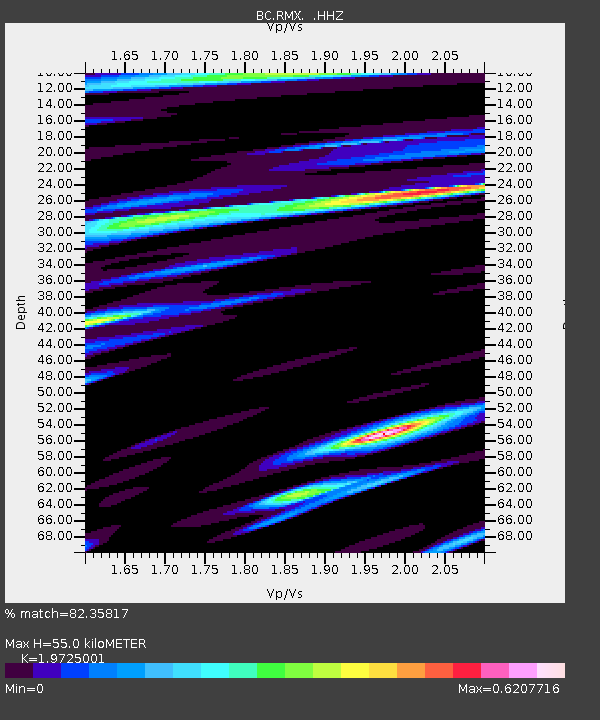
| Estimated Moho Depth: |
55.0 km |
| Estimated Crust Vp/Vs: |
1.97 |
| Assumed Crust Vp: |
6.264 km/s |
| Estimated Crust Vs: |
3.175 km/s |
| Estimated Crust Poisson's Ratio: |
0.33 |
|
| Radial Match: |
82.35817 % |
| Radial Bump: |
400 |
| Transverse Match: |
75.22446 % |
| Transverse Bump: |
400 |
| SOD ConfigId: |
795072 |
| Insert Time: |
2014-10-01 08:22:53.796 +0000 |
| GWidth: |
2.5 |
| Max Bumps: |
400 |
| Tol: |
0.001 |
|

Signal To Noise
| Channel | StoN | STA | LTA |
| BC:RMX: :HHZ:20140917T06:27:01.619983Z | 31.979242 | 8.392956E-6 | 2.6245013E-7 |
| BC:RMX: :HHN:20140917T06:27:01.619983Z | 7.8831162 | 1.0931575E-6 | 1.3867073E-7 |
| BC:RMX: :HHE:20140917T06:27:01.619983Z | 2.6691515 | 1.474114E-6 | 5.522781E-7 |
| Arrivals |
| Ps | 8.7 SECOND |
| PpPs | 26 SECOND |
| PsPs/PpSs | 34 SECOND |


