You are here: Home > Network List > IU - Global Seismograph Network (GSN - IRIS/USGS) Stations List
> Station AFI Afiamalu, Western Samoa > Earthquake Result Viewer
AFI Afiamalu, Western Samoa - Earthquake Result Viewer
| Earthquake location: |
Banda Sea |
| Earthquake latitude/longitude: |
-4.1/123.9 |
| Earthquake time(UTC): |
2001/10/19 (292) 03:28:44 GMT |
| Earthquake Depth: |
33 km |
| Earthquake Magnitude: |
6.3 MB, 7.3 MS, 7.5 MW, 7.4 MW |
| Earthquake Catalog/Contributor: |
WHDF/NEIC |
|
| Network: |
IU Global Seismograph Network (GSN - IRIS/USGS) |
| Station: |
AFI Afiamalu, Western Samoa |
| Lat/Lon: |
13.91 S/171.78 W |
| Elevation: |
706 m |
|
| Distance: |
64.1 deg |
| Az: |
103.393 deg |
| Baz: |
272.183 deg |
| Ray Param: |
0.059086405 |
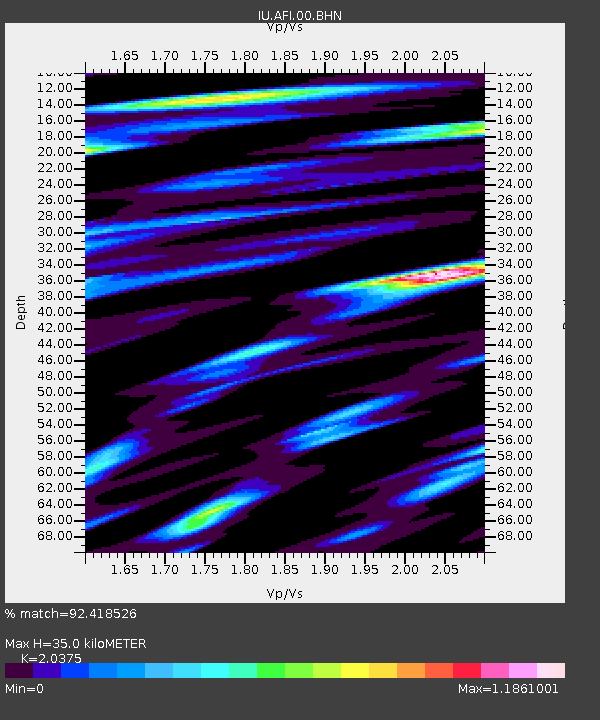
| Estimated Moho Depth: |
35.0 km |
| Estimated Crust Vp/Vs: |
2.04 |
| Assumed Crust Vp: |
4.24 km/s |
| Estimated Crust Vs: |
2.081 km/s |
| Estimated Crust Poisson's Ratio: |
0.34 |
|
| Radial Match: |
92.418526 % |
| Radial Bump: |
400 |
| Transverse Match: |
92.42256 % |
| Transverse Bump: |
400 |
| SOD ConfigId: |
20082 |
| Insert Time: |
2010-03-02 01:44:40.814 +0000 |
| GWidth: |
2.5 |
| Max Bumps: |
400 |
| Tol: |
0.001 |
|
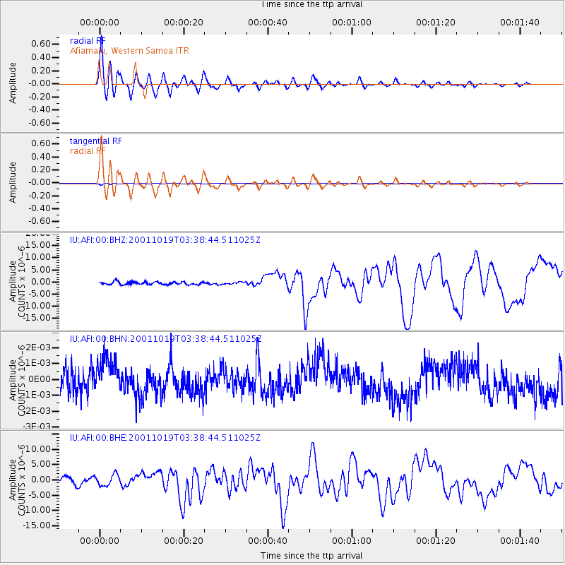
Signal To Noise
| Channel | StoN | STA | LTA |
| IU:AFI:00:BHN:20011019T03:38:44.511025Z | 1.4256387 | 1.1388168E-9 | 7.9881163E-10 |
| IU:AFI:00:BHE:20011019T03:38:44.511025Z | 1.5349802 | 1.8275226E-6 | 1.1905839E-6 |
| IU:AFI:00:BHZ:20011019T03:38:44.511025Z | 0.7171892 | 4.020811E-7 | 5.6063465E-7 |
| Arrivals |
| Ps | 8.7 SECOND |
| PpPs | 25 SECOND |
| PsPs/PpSs | 33 SECOND |


