You are here: Home > Network List > TA - USArray Transportable Network (new EarthScope stations) Stations List
> Station A21K Barrow, AK, USA > Earthquake Result Viewer
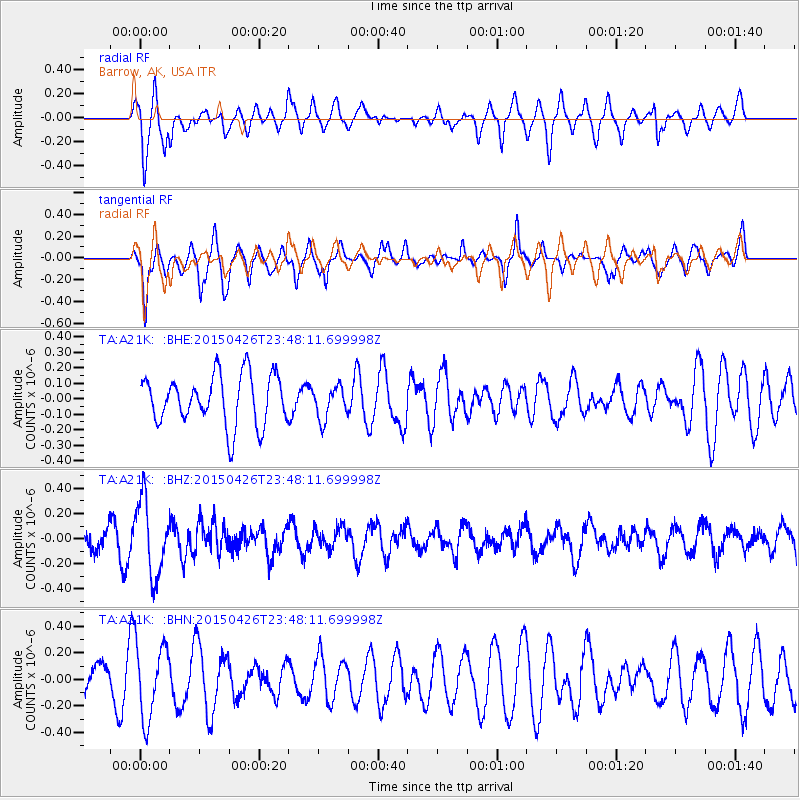
A21K Barrow, AK, USA - Earthquake Result Viewer
*The percent match for this event was below the threshold and hence no stack was calculated.
| Earthquake location: |
Near Coast Of Northern Peru |
| Earthquake latitude/longitude: |
-8.3/-79.8 |
| Earthquake time(UTC): |
2015/04/26 (116) 23:35:29 GMT |
| Earthquake Depth: |
22 km |
| Earthquake Magnitude: |
5.6 MWW, 5.6 MWB, 5.7 MWC |
| Earthquake Catalog/Contributor: |
NEIC PDE/NEIC COMCAT |
|
| Network: |
TA USArray Transportable Network (new EarthScope stations) |
| Station: |
A21K Barrow, AK, USA |
| Lat/Lon: |
71.32 N/156.62 W |
| Elevation: |
577 m |
|
| Distance: |
93.6 deg |
| Az: |
341.681 deg |
| Baz: |
105.107 deg |
| Ray Param: |
$rayparam |
*The percent match for this event was below the threshold and hence was not used in the summary stack. |
|
| Radial Match: |
52.285416 % |
| Radial Bump: |
341 |
| Transverse Match: |
71.64189 % |
| Transverse Bump: |
297 |
| SOD ConfigId: |
7422571 |
| Insert Time: |
2019-04-18 13:13:59.308 +0000 |
| GWidth: |
2.5 |
| Max Bumps: |
400 |
| Tol: |
0.001 |
|
Signal To Noise
| Channel | StoN | STA | LTA |
| TA:A21K: :BHZ:20150426T23:48:11.699998Z | 2.4126227 | 2.9854485E-7 | 1.2374286E-7 |
| TA:A21K: :BHN:20150426T23:48:11.699998Z | 1.7132857 | 2.774426E-7 | 1.6193599E-7 |
| TA:A21K: :BHE:20150426T23:48:11.699998Z | 0.67255336 | 1.07879785E-7 | 1.6040332E-7 |
| Arrivals |
| Ps | |
| PpPs | |
| PsPs/PpSs | |


