You are here: Home > Network List > TA - USArray Transportable Network (new EarthScope stations) Stations List
> Station D58A Chemin du LacGrosbois, Trois-Rives, QC, CAN > Earthquake Result Viewer
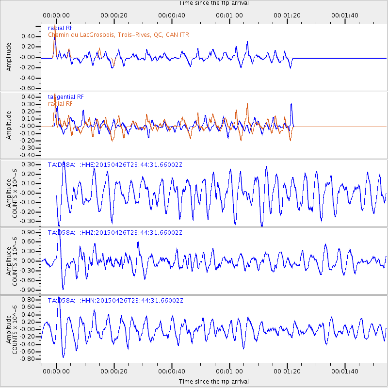
D58A Chemin du LacGrosbois, Trois-Rives, QC, CAN - Earthquake Result Viewer
*The percent match for this event was below the threshold and hence no stack was calculated.
| Earthquake location: |
Near Coast Of Northern Peru |
| Earthquake latitude/longitude: |
-8.3/-79.8 |
| Earthquake time(UTC): |
2015/04/26 (116) 23:35:29 GMT |
| Earthquake Depth: |
22 km |
| Earthquake Magnitude: |
5.6 MWW, 5.6 MWB, 5.7 MWC |
| Earthquake Catalog/Contributor: |
NEIC PDE/NEIC COMCAT |
|
| Network: |
TA USArray Transportable Network (new EarthScope stations) |
| Station: |
D58A Chemin du LacGrosbois, Trois-Rives, QC, CAN |
| Lat/Lon: |
47.10 N/72.88 W |
| Elevation: |
398 m |
|
| Distance: |
55.5 deg |
| Az: |
5.742 deg |
| Baz: |
188.332 deg |
| Ray Param: |
$rayparam |
*The percent match for this event was below the threshold and hence was not used in the summary stack. |
|
| Radial Match: |
68.234085 % |
| Radial Bump: |
283 |
| Transverse Match: |
69.79923 % |
| Transverse Bump: |
345 |
| SOD ConfigId: |
7422571 |
| Insert Time: |
2019-04-18 13:14:03.677 +0000 |
| GWidth: |
2.5 |
| Max Bumps: |
400 |
| Tol: |
0.001 |
|
Signal To Noise
| Channel | StoN | STA | LTA |
| TA:D58A: :HHZ:20150426T23:44:31.66002Z | 3.6211004 | 4.976899E-7 | 1.3744162E-7 |
| TA:D58A: :HHN:20150426T23:44:31.66002Z | 3.367402 | 4.7439968E-7 | 1.4088003E-7 |
| TA:D58A: :HHE:20150426T23:44:31.66002Z | 0.7151578 | 1.04506796E-7 | 1.461311E-7 |
| Arrivals |
| Ps | |
| PpPs | |
| PsPs/PpSs | |


