You are here: Home > Network List > TA - USArray Transportable Network (new EarthScope stations) Stations List
> Station H17A Grant Village (NPS), Yellowstone Nt. Park, WY, USA > Earthquake Result Viewer
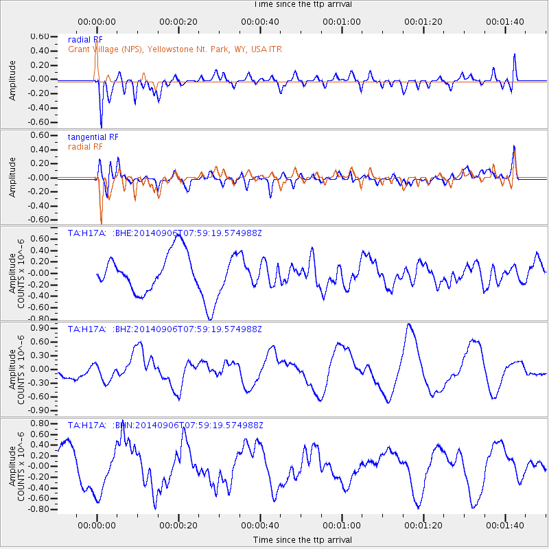
H17A Grant Village (NPS), Yellowstone Nt. Park, WY, USA - Earthquake Result Viewer
*The percent match for this event was below the threshold and hence no stack was calculated.
| Earthquake location: |
Easter Island Region |
| Earthquake latitude/longitude: |
-26.8/-114.5 |
| Earthquake time(UTC): |
2014/09/06 (249) 07:48:33 GMT |
| Earthquake Depth: |
10 km |
| Earthquake Magnitude: |
5.9 MWW, 5.8 MWC |
| Earthquake Catalog/Contributor: |
NEIC PDE/NEIC COMCAT |
|
| Network: |
TA USArray Transportable Network (new EarthScope stations) |
| Station: |
H17A Grant Village (NPS), Yellowstone Nt. Park, WY, USA |
| Lat/Lon: |
44.40 N/110.58 W |
| Elevation: |
2400 m |
|
| Distance: |
70.9 deg |
| Az: |
2.954 deg |
| Baz: |
183.685 deg |
| Ray Param: |
$rayparam |
*The percent match for this event was below the threshold and hence was not used in the summary stack. |
|
| Radial Match: |
53.499077 % |
| Radial Bump: |
400 |
| Transverse Match: |
40.59258 % |
| Transverse Bump: |
400 |
| SOD ConfigId: |
795072 |
| Insert Time: |
2014-10-03 11:59:49.500 +0000 |
| GWidth: |
2.5 |
| Max Bumps: |
400 |
| Tol: |
0.001 |
|
Signal To Noise
| Channel | StoN | STA | LTA |
| TA:H17A: :BHZ:20140906T07:59:19.574988Z | 1.112541 | 1.9600861E-7 | 1.7618105E-7 |
| TA:H17A: :BHN:20140906T07:59:19.574988Z | 1.7860307 | 4.3260934E-7 | 2.422183E-7 |
| TA:H17A: :BHE:20140906T07:59:19.574988Z | 1.0069118 | 3.1350945E-7 | 3.1135744E-7 |
| Arrivals |
| Ps | |
| PpPs | |
| PsPs/PpSs | |


