You are here: Home > Network List > TA - USArray Transportable Network (new EarthScope stations) Stations List
> Station S56A Natural Bridge, VA, USA > Earthquake Result Viewer
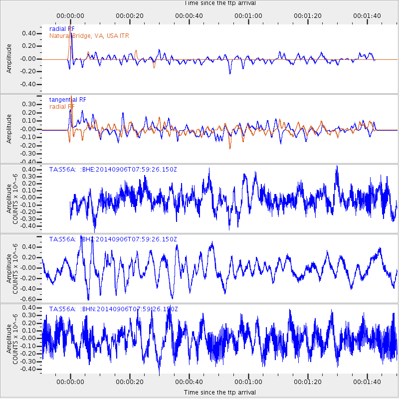
S56A Natural Bridge, VA, USA - Earthquake Result Viewer
*The percent match for this event was below the threshold and hence no stack was calculated.
| Earthquake location: |
Easter Island Region |
| Earthquake latitude/longitude: |
-26.8/-114.5 |
| Earthquake time(UTC): |
2014/09/06 (249) 07:48:33 GMT |
| Earthquake Depth: |
10 km |
| Earthquake Magnitude: |
5.9 MWW, 5.8 MWC |
| Earthquake Catalog/Contributor: |
NEIC PDE/NEIC COMCAT |
|
| Network: |
TA USArray Transportable Network (new EarthScope stations) |
| Station: |
S56A Natural Bridge, VA, USA |
| Lat/Lon: |
37.68 N/79.57 W |
| Elevation: |
449 m |
|
| Distance: |
72.0 deg |
| Az: |
28.517 deg |
| Baz: |
212.545 deg |
| Ray Param: |
$rayparam |
*The percent match for this event was below the threshold and hence was not used in the summary stack. |
|
| Radial Match: |
53.18489 % |
| Radial Bump: |
400 |
| Transverse Match: |
49.64203 % |
| Transverse Bump: |
400 |
| SOD ConfigId: |
795072 |
| Insert Time: |
2014-10-03 12:02:38.219 +0000 |
| GWidth: |
2.5 |
| Max Bumps: |
400 |
| Tol: |
0.001 |
|
Signal To Noise
| Channel | StoN | STA | LTA |
| TA:S56A: :BHZ:20140906T07:59:26.150Z | 1.7212517 | 2.603378E-7 | 1.5124911E-7 |
| TA:S56A: :BHN:20140906T07:59:26.150Z | 1.0368084 | 1.4027614E-7 | 1.352961E-7 |
| TA:S56A: :BHE:20140906T07:59:26.150Z | 0.86609316 | 1.0974841E-7 | 1.2671664E-7 |
| Arrivals |
| Ps | |
| PpPs | |
| PsPs/PpSs | |


