You are here: Home > Network List > TA - USArray Transportable Network (new EarthScope stations) Stations List
> Station G60A Masonville, QC, CAN > Earthquake Result Viewer
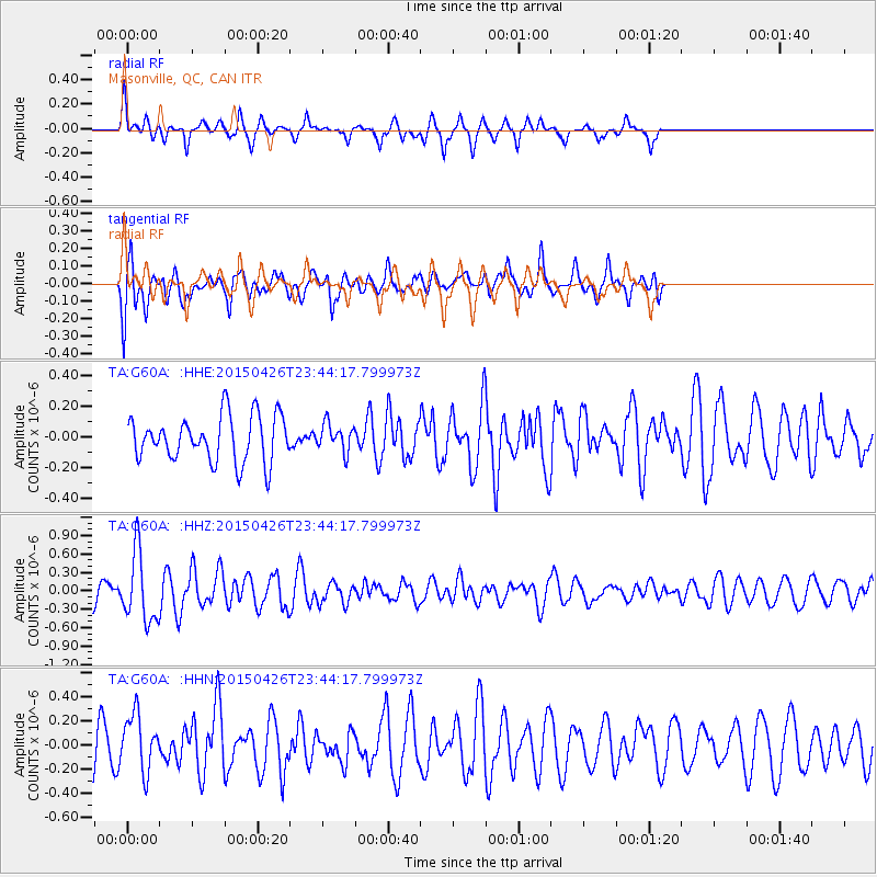
G60A Masonville, QC, CAN - Earthquake Result Viewer
*The percent match for this event was below the threshold and hence no stack was calculated.
| Earthquake location: |
Near Coast Of Northern Peru |
| Earthquake latitude/longitude: |
-8.3/-79.8 |
| Earthquake time(UTC): |
2015/04/26 (116) 23:35:29 GMT |
| Earthquake Depth: |
22 km |
| Earthquake Magnitude: |
5.6 MWW, 5.6 MWB, 5.7 MWC |
| Earthquake Catalog/Contributor: |
NEIC PDE/NEIC COMCAT |
|
| Network: |
TA USArray Transportable Network (new EarthScope stations) |
| Station: |
G60A Masonville, QC, CAN |
| Lat/Lon: |
45.10 N/72.33 W |
| Elevation: |
391 m |
|
| Distance: |
53.6 deg |
| Az: |
6.579 deg |
| Baz: |
189.212 deg |
| Ray Param: |
$rayparam |
*The percent match for this event was below the threshold and hence was not used in the summary stack. |
|
| Radial Match: |
57.925243 % |
| Radial Bump: |
246 |
| Transverse Match: |
61.31066 % |
| Transverse Bump: |
400 |
| SOD ConfigId: |
7422571 |
| Insert Time: |
2019-04-18 13:14:17.176 +0000 |
| GWidth: |
2.5 |
| Max Bumps: |
400 |
| Tol: |
0.001 |
|
Signal To Noise
| Channel | StoN | STA | LTA |
| TA:G60A: :HHZ:20150426T23:44:17.799973Z | 4.3614836 | 5.6441706E-7 | 1.2940941E-7 |
| TA:G60A: :HHN:20150426T23:44:17.799973Z | 1.1403383 | 2.3474823E-7 | 2.0585843E-7 |
| TA:G60A: :HHE:20150426T23:44:17.799973Z | 0.6141719 | 9.117121E-8 | 1.4844575E-7 |
| Arrivals |
| Ps | |
| PpPs | |
| PsPs/PpSs | |


