You are here: Home > Network List > TA - USArray Transportable Network (new EarthScope stations) Stations List
> Station H17A Grant Village (NPS), Yellowstone Nt. Park, WY, USA > Earthquake Result Viewer
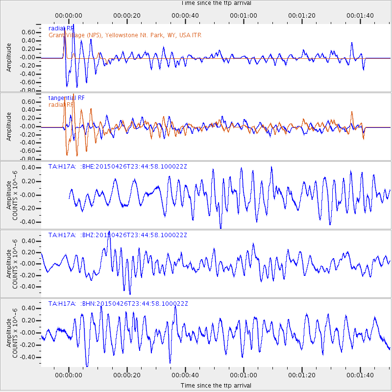
H17A Grant Village (NPS), Yellowstone Nt. Park, WY, USA - Earthquake Result Viewer
*The percent match for this event was below the threshold and hence no stack was calculated.
| Earthquake location: |
Near Coast Of Northern Peru |
| Earthquake latitude/longitude: |
-8.3/-79.8 |
| Earthquake time(UTC): |
2015/04/26 (116) 23:35:29 GMT |
| Earthquake Depth: |
22 km |
| Earthquake Magnitude: |
5.6 MWW, 5.6 MWB, 5.7 MWC |
| Earthquake Catalog/Contributor: |
NEIC PDE/NEIC COMCAT |
|
| Network: |
TA USArray Transportable Network (new EarthScope stations) |
| Station: |
H17A Grant Village (NPS), Yellowstone Nt. Park, WY, USA |
| Lat/Lon: |
44.40 N/110.58 W |
| Elevation: |
2400 m |
|
| Distance: |
59.4 deg |
| Az: |
334.776 deg |
| Baz: |
143.963 deg |
| Ray Param: |
$rayparam |
*The percent match for this event was below the threshold and hence was not used in the summary stack. |
|
| Radial Match: |
68.5249 % |
| Radial Bump: |
400 |
| Transverse Match: |
57.578125 % |
| Transverse Bump: |
400 |
| SOD ConfigId: |
7422571 |
| Insert Time: |
2019-04-18 13:14:22.240 +0000 |
| GWidth: |
2.5 |
| Max Bumps: |
400 |
| Tol: |
0.001 |
|
Signal To Noise
| Channel | StoN | STA | LTA |
| TA:H17A: :BHZ:20150426T23:44:58.100022Z | 0.8867159 | 1.0250696E-7 | 1.1560294E-7 |
| TA:H17A: :BHN:20150426T23:44:58.100022Z | 2.043733 | 1.6433836E-7 | 8.041088E-8 |
| TA:H17A: :BHE:20150426T23:44:58.100022Z | 1.4772058 | 1.714529E-7 | 1.16065685E-7 |
| Arrivals |
| Ps | |
| PpPs | |
| PsPs/PpSs | |


