You are here: Home > Network List > TA - USArray Transportable Network (new EarthScope stations) Stations List
> Station I61A Oroboro, Fairlee, VT, USA > Earthquake Result Viewer
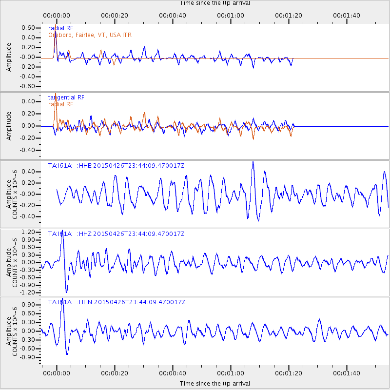
I61A Oroboro, Fairlee, VT, USA - Earthquake Result Viewer
*The percent match for this event was below the threshold and hence no stack was calculated.
| Earthquake location: |
Near Coast Of Northern Peru |
| Earthquake latitude/longitude: |
-8.3/-79.8 |
| Earthquake time(UTC): |
2015/04/26 (116) 23:35:29 GMT |
| Earthquake Depth: |
22 km |
| Earthquake Magnitude: |
5.6 MWW, 5.6 MWB, 5.7 MWC |
| Earthquake Catalog/Contributor: |
NEIC PDE/NEIC COMCAT |
|
| Network: |
TA USArray Transportable Network (new EarthScope stations) |
| Station: |
I61A Oroboro, Fairlee, VT, USA |
| Lat/Lon: |
43.93 N/72.21 W |
| Elevation: |
287 m |
|
| Distance: |
52.4 deg |
| Az: |
6.927 deg |
| Baz: |
189.509 deg |
| Ray Param: |
$rayparam |
*The percent match for this event was below the threshold and hence was not used in the summary stack. |
|
| Radial Match: |
51.685608 % |
| Radial Bump: |
272 |
| Transverse Match: |
32.235497 % |
| Transverse Bump: |
331 |
| SOD ConfigId: |
7422571 |
| Insert Time: |
2019-04-18 13:14:32.635 +0000 |
| GWidth: |
2.5 |
| Max Bumps: |
400 |
| Tol: |
0.001 |
|
Signal To Noise
| Channel | StoN | STA | LTA |
| TA:I61A: :HHZ:20150426T23:44:09.470017Z | 4.323903 | 6.514248E-7 | 1.5065665E-7 |
| TA:I61A: :HHN:20150426T23:44:09.470017Z | 5.079043 | 5.6518587E-7 | 1.1127803E-7 |
| TA:I61A: :HHE:20150426T23:44:09.470017Z | 0.60146654 | 8.900358E-8 | 1.4797762E-7 |
| Arrivals |
| Ps | |
| PpPs | |
| PsPs/PpSs | |


