You are here: Home > Network List > IU - Global Seismograph Network (GSN - IRIS/USGS) Stations List
> Station AFI Afiamalu, Western Samoa > Earthquake Result Viewer
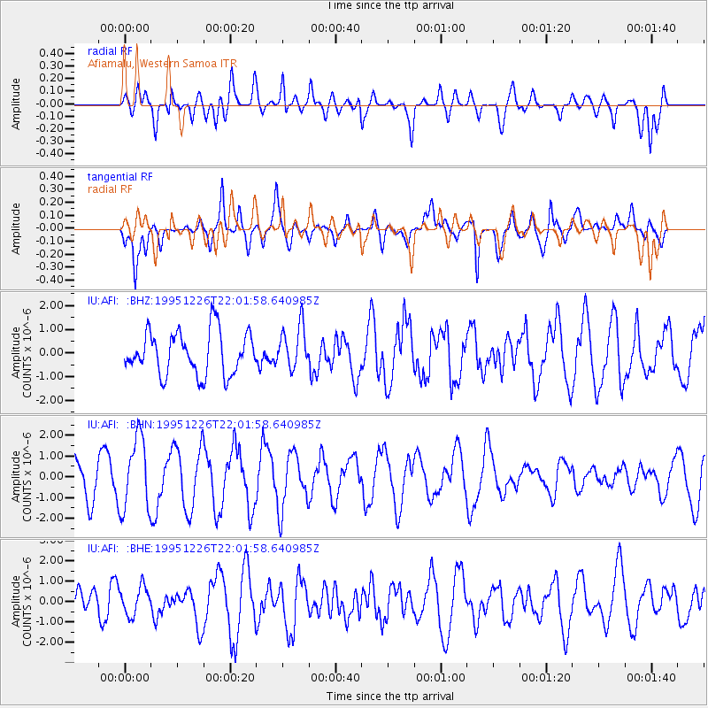
AFI Afiamalu, Western Samoa - Earthquake Result Viewer
*The percent match for this event was below the threshold and hence no stack was calculated.
| Earthquake location: |
New Britain Region, P.N.G. |
| Earthquake latitude/longitude: |
-5.2/151.4 |
| Earthquake time(UTC): |
1995/12/26 (360) 21:55:20 GMT |
| Earthquake Depth: |
33 km |
| Earthquake Magnitude: |
5.8 UNKNOWN, 5.4 MS, 5.4 MB |
| Earthquake Catalog/Contributor: |
WHDF/NEIC |
|
| Network: |
IU Global Seismograph Network (GSN - IRIS/USGS) |
| Station: |
AFI Afiamalu, Western Samoa |
| Lat/Lon: |
13.91 S/171.78 W |
| Elevation: |
706 m |
|
| Distance: |
37.2 deg |
| Az: |
106.117 deg |
| Baz: |
279.826 deg |
| Ray Param: |
$rayparam |
*The percent match for this event was below the threshold and hence was not used in the summary stack. |
|
| Radial Match: |
56.896313 % |
| Radial Bump: |
400 |
| Transverse Match: |
62.44734 % |
| Transverse Bump: |
400 |
| SOD ConfigId: |
4480 |
| Insert Time: |
2010-03-02 01:45:13.764 +0000 |
| GWidth: |
2.5 |
| Max Bumps: |
400 |
| Tol: |
0.001 |
|
Signal To Noise
| Channel | StoN | STA | LTA |
| IU:AFI: :BHN:19951226T22:01:58.640985Z | 1.4886031 | 1.7530183E-6 | 1.1776264E-6 |
| IU:AFI: :BHE:19951226T22:01:58.640985Z | 0.8465227 | 7.6110405E-7 | 8.990947E-7 |
| IU:AFI: :BHZ:19951226T22:01:58.640985Z | 0.9967533 | 9.0277086E-7 | 9.057115E-7 |
| Arrivals |
| Ps | |
| PpPs | |
| PsPs/PpSs | |


