You are here: Home > Network List > TA - USArray Transportable Network (new EarthScope stations) Stations List
> Station N60A Cedar Hill Farm, Mount Bethel, PA, USA > Earthquake Result Viewer
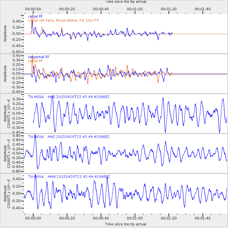
N60A Cedar Hill Farm, Mount Bethel, PA, USA - Earthquake Result Viewer
*The percent match for this event was below the threshold and hence no stack was calculated.
| Earthquake location: |
Near Coast Of Northern Peru |
| Earthquake latitude/longitude: |
-8.3/-79.8 |
| Earthquake time(UTC): |
2015/04/26 (116) 23:35:29 GMT |
| Earthquake Depth: |
22 km |
| Earthquake Magnitude: |
5.6 MWW, 5.6 MWB, 5.7 MWC |
| Earthquake Catalog/Contributor: |
NEIC PDE/NEIC COMCAT |
|
| Network: |
TA USArray Transportable Network (new EarthScope stations) |
| Station: |
N60A Cedar Hill Farm, Mount Bethel, PA, USA |
| Lat/Lon: |
40.87 N/75.10 W |
| Elevation: |
189 m |
|
| Distance: |
49.1 deg |
| Az: |
4.727 deg |
| Baz: |
186.174 deg |
| Ray Param: |
$rayparam |
*The percent match for this event was below the threshold and hence was not used in the summary stack. |
|
| Radial Match: |
38.81491 % |
| Radial Bump: |
300 |
| Transverse Match: |
44.994884 % |
| Transverse Bump: |
344 |
| SOD ConfigId: |
7422571 |
| Insert Time: |
2019-04-18 13:15:06.037 +0000 |
| GWidth: |
2.5 |
| Max Bumps: |
400 |
| Tol: |
0.001 |
|
Signal To Noise
| Channel | StoN | STA | LTA |
| TA:N60A: :HHZ:20150426T23:43:44.439988Z | 1.9385092 | 4.417034E-7 | 2.2785727E-7 |
| TA:N60A: :HHN:20150426T23:43:44.439988Z | 1.427684 | 2.5932422E-7 | 1.816398E-7 |
| TA:N60A: :HHE:20150426T23:43:44.439988Z | 0.5787597 | 9.7609075E-8 | 1.6865218E-7 |
| Arrivals |
| Ps | |
| PpPs | |
| PsPs/PpSs | |


