You are here: Home > Network List > UW - Pacific Northwest Regional Seismic Network Stations List
> Station MRBL Marblemount, WA, USA > Earthquake Result Viewer
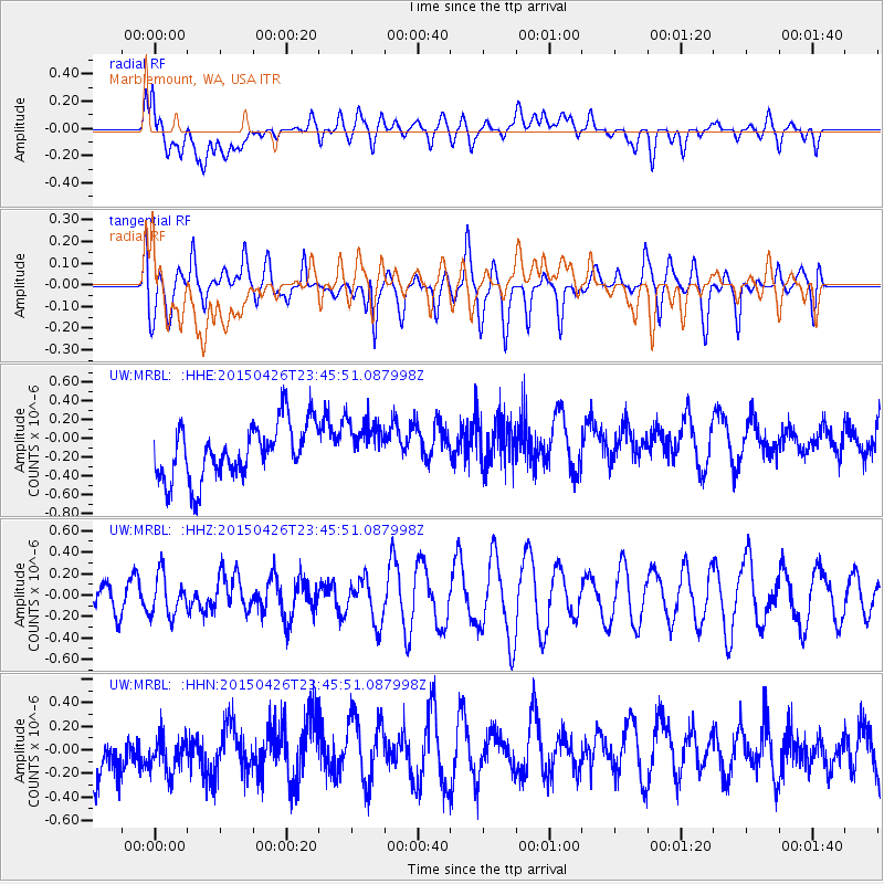
MRBL Marblemount, WA, USA - Earthquake Result Viewer
*The percent match for this event was below the threshold and hence no stack was calculated.
| Earthquake location: |
Near Coast Of Northern Peru |
| Earthquake latitude/longitude: |
-8.3/-79.8 |
| Earthquake time(UTC): |
2015/04/26 (116) 23:35:29 GMT |
| Earthquake Depth: |
22 km |
| Earthquake Magnitude: |
5.6 MWW, 5.6 MWB, 5.7 MWC |
| Earthquake Catalog/Contributor: |
NEIC PDE/NEIC COMCAT |
|
| Network: |
UW Pacific Northwest Regional Seismic Network |
| Station: |
MRBL Marblemount, WA, USA |
| Lat/Lon: |
48.52 N/121.48 W |
| Elevation: |
75 m |
|
| Distance: |
67.4 deg |
| Az: |
331.392 deg |
| Baz: |
134.545 deg |
| Ray Param: |
$rayparam |
*The percent match for this event was below the threshold and hence was not used in the summary stack. |
|
| Radial Match: |
57.4444 % |
| Radial Bump: |
400 |
| Transverse Match: |
45.87612 % |
| Transverse Bump: |
400 |
| SOD ConfigId: |
7422571 |
| Insert Time: |
2019-04-18 13:15:57.975 +0000 |
| GWidth: |
2.5 |
| Max Bumps: |
400 |
| Tol: |
0.001 |
|
Signal To Noise
| Channel | StoN | STA | LTA |
| UW:MRBL: :HHZ:20150426T23:45:51.087998Z | 1.1468854 | 1.8954803E-7 | 1.6527198E-7 |
| UW:MRBL: :HHN:20150426T23:45:51.087998Z | 0.7362881 | 1.7428043E-7 | 2.3670141E-7 |
| UW:MRBL: :HHE:20150426T23:45:51.087998Z | 0.6741035 | 2.0092816E-7 | 2.9806722E-7 |
| Arrivals |
| Ps | |
| PpPs | |
| PsPs/PpSs | |


