You are here: Home > Network List > 7A - Mid-Atlantic Geophysical Integrative Collaboration Stations List
> Station JSPR Franklin, West Virginia USA > Earthquake Result Viewer
JSPR Franklin, West Virginia USA - Earthquake Result Viewer
| Earthquake location: |
Kuril Islands |
| Earthquake latitude/longitude: |
45.0/150.9 |
| Earthquake time(UTC): |
2015/04/27 (117) 01:51:17 GMT |
| Earthquake Depth: |
100 km |
| Earthquake Magnitude: |
4.2 mb, 3.9 mb |
| Earthquake Catalog/Contributor: |
ISC/ISC |
|
| Network: |
7A Mid-Atlantic Geophysical Integrative Collaboration |
| Station: |
JSPR Franklin, West Virginia USA |
| Lat/Lon: |
38.64 N/79.33 W |
| Elevation: |
527 m |
|
| Distance: |
85.2 deg |
| Az: |
37.175 deg |
| Baz: |
326.832 deg |
| Ray Param: |
0.04471073 |
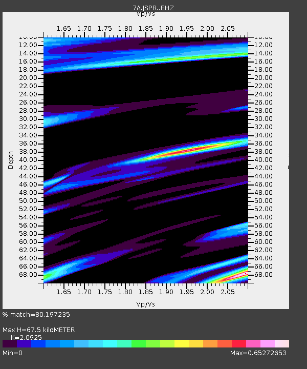
| Estimated Moho Depth: |
67.5 km |
| Estimated Crust Vp/Vs: |
2.09 |
| Assumed Crust Vp: |
6.159 km/s |
| Estimated Crust Vs: |
2.943 km/s |
| Estimated Crust Poisson's Ratio: |
0.35 |
|
| Radial Match: |
80.197235 % |
| Radial Bump: |
400 |
| Transverse Match: |
54.347717 % |
| Transverse Bump: |
400 |
| SOD ConfigId: |
7422571 |
| Insert Time: |
2019-04-18 13:17:42.232 +0000 |
| GWidth: |
2.5 |
| Max Bumps: |
400 |
| Tol: |
0.001 |
|

Signal To Noise
| Channel | StoN | STA | LTA |
| 7A:JSPR: :BHZ:20150427T02:03:11.399971Z | 1.646306 | 3.3807163E-7 | 2.0535163E-7 |
| 7A:JSPR: :BHN:20150427T02:03:11.399971Z | 2.1303463 | 3.8940664E-7 | 1.827903E-7 |
| 7A:JSPR: :BHE:20150427T02:03:11.399971Z | 0.5334466 | 1.0583165E-7 | 1.9839221E-7 |
| Arrivals |
| Ps | 12 SECOND |
| PpPs | 33 SECOND |
| PsPs/PpSs | 45 SECOND |


