You are here: Home > Network List > IU - Global Seismograph Network (GSN - IRIS/USGS) Stations List
> Station TEIG Tepich, Yucatan, Mexico > Earthquake Result Viewer
TEIG Tepich, Yucatan, Mexico - Earthquake Result Viewer
| Earthquake location: |
Jujuy Province, Argentina |
| Earthquake latitude/longitude: |
-23.9/-66.6 |
| Earthquake time(UTC): |
2014/09/24 (267) 11:16:12 GMT |
| Earthquake Depth: |
189 km |
| Earthquake Magnitude: |
6.2 MWP, 6.2 MWB, 6.2 MWC |
| Earthquake Catalog/Contributor: |
NEIC PDE/NEIC COMCAT |
|
| Network: |
IU Global Seismograph Network (GSN - IRIS/USGS) |
| Station: |
TEIG Tepich, Yucatan, Mexico |
| Lat/Lon: |
20.23 N/88.28 W |
| Elevation: |
40 m |
|
| Distance: |
48.7 deg |
| Az: |
332.422 deg |
| Baz: |
153.169 deg |
| Ray Param: |
0.06851319 |
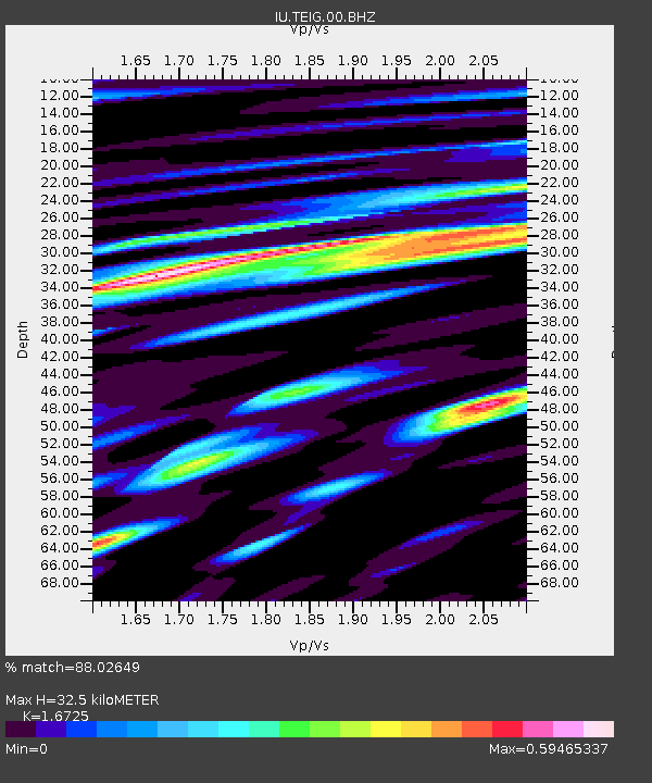
| Estimated Moho Depth: |
32.5 km |
| Estimated Crust Vp/Vs: |
1.67 |
| Assumed Crust Vp: |
5.817 km/s |
| Estimated Crust Vs: |
3.478 km/s |
| Estimated Crust Poisson's Ratio: |
0.22 |
|
| Radial Match: |
88.02649 % |
| Radial Bump: |
400 |
| Transverse Match: |
70.192055 % |
| Transverse Bump: |
400 |
| SOD ConfigId: |
796777 |
| Insert Time: |
2014-10-08 11:40:32.590 +0000 |
| GWidth: |
2.5 |
| Max Bumps: |
400 |
| Tol: |
0.001 |
|

Signal To Noise
| Channel | StoN | STA | LTA |
| IU:TEIG:00:BHZ:20140924T11:24:06.460011Z | 31.876097 | 3.6250267E-6 | 1.1372242E-7 |
| IU:TEIG:00:BH1:20140924T11:24:06.460011Z | 0.4610351 | 5.6429812E-8 | 1.2239808E-7 |
| IU:TEIG:00:BH2:20140924T11:24:06.460011Z | 13.484579 | 1.6582557E-6 | 1.2297423E-7 |
| Arrivals |
| Ps | 4.0 SECOND |
| PpPs | 14 SECOND |
| PsPs/PpSs | 18 SECOND |


