You are here: Home > Network List > CI - Caltech Regional Seismic Network Stations List
> Station CWC CWC, Lone Pine, CA, USA > Earthquake Result Viewer
CWC CWC, Lone Pine, CA, USA - Earthquake Result Viewer

| Earthquake location: |
New Britain Region, P.N.G. |
| Earthquake latitude/longitude: |
-5.5/151.8 |
| Earthquake time(UTC): |
2000/11/17 (322) 21:01:56 GMT |
| Earthquake Depth: |
33 km |
| Earthquake Magnitude: |
6.2 MB, 8.0 MS, 7.6 MW, 6.9 ME |
| Earthquake Catalog/Contributor: |
WHDF/NEIC |
|
| Network: |
CI Caltech Regional Seismic Network |
| Station: |
CWC CWC, Lone Pine, CA, USA |
| Lat/Lon: |
36.44 N/118.08 W |
| Elevation: |
1595 m |
|
| Distance: |
93.3 deg |
| Az: |
53.877 deg |
| Baz: |
265.675 deg |
| Ray Param: |
0.04126977 |
| Estimated Moho Depth: |
49.0 km |
| Estimated Crust Vp/Vs: |
1.60 |
| Assumed Crust Vp: |
6.291 km/s |
| Estimated Crust Vs: |
3.926 km/s |
| Estimated Crust Poisson's Ratio: |
0.18 |
|
| Radial Match: |
93.345955 % |
| Radial Bump: |
400 |
| Transverse Match: |
81.784805 % |
| Transverse Bump: |
400 |
| SOD ConfigId: |
3787 |
| Insert Time: |
2010-02-25 21:16:41.562 +0000 |
| GWidth: |
2.5 |
| Max Bumps: |
400 |
| Tol: |
0.001 |
|
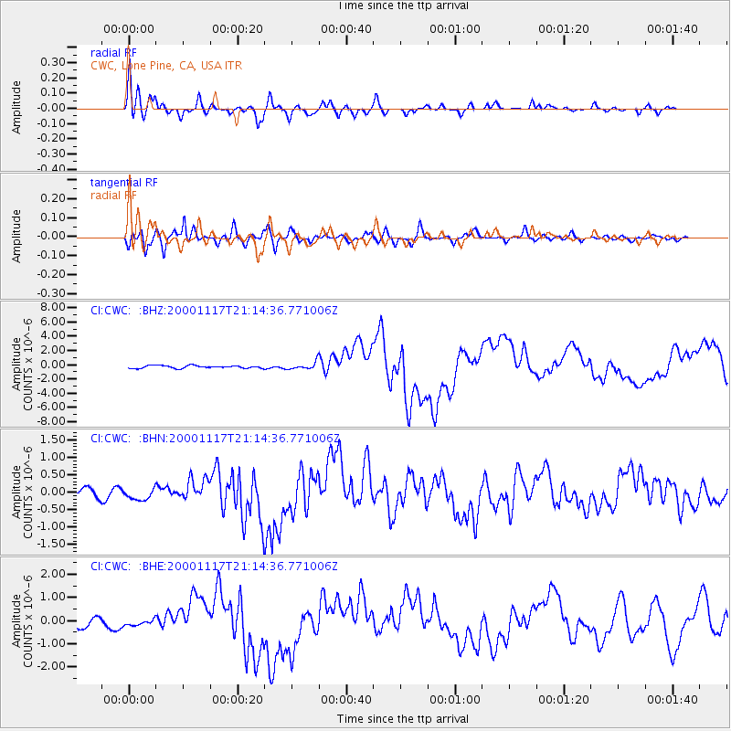
Signal To Noise
| Channel | StoN | STA | LTA |
| CI:CWC: :BHN:20001117T21:14:36.771006Z | 1.6361177 | 1.6385141E-7 | 1.0014647E-7 |
| CI:CWC: :BHE:20001117T21:14:36.771006Z | 0.80848 | 1.5879489E-7 | 1.9641163E-7 |
| CI:CWC: :BHZ:20001117T21:14:36.771006Z | 2.652597 | 5.058858E-7 | 1.9071341E-7 |
| Arrivals |
| Ps | 4.8 SECOND |
| PpPs | 20 SECOND |
| PsPs/PpSs | 25 SECOND |


