You are here: Home > Network List > IU - Global Seismograph Network (GSN - IRIS/USGS) Stations List
> Station JOHN Johnston Island, USA > Earthquake Result Viewer
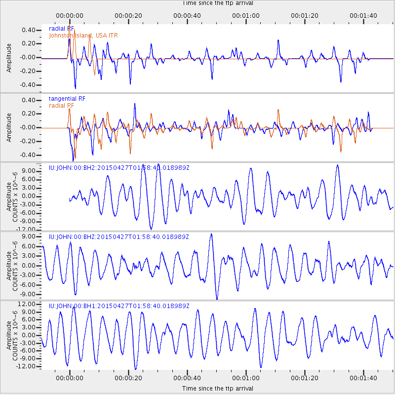
JOHN Johnston Island, USA - Earthquake Result Viewer
*The percent match for this event was below the threshold and hence no stack was calculated.
| Earthquake location: |
Kuril Islands |
| Earthquake latitude/longitude: |
45.0/150.9 |
| Earthquake time(UTC): |
2015/04/27 (117) 01:51:17 GMT |
| Earthquake Depth: |
100 km |
| Earthquake Magnitude: |
4.2 mb, 3.9 mb |
| Earthquake Catalog/Contributor: |
ISC/ISC |
|
| Network: |
IU Global Seismograph Network (GSN - IRIS/USGS) |
| Station: |
JOHN Johnston Island, USA |
| Lat/Lon: |
16.73 N/169.53 W |
| Elevation: |
2.0 m |
|
| Distance: |
43.5 deg |
| Az: |
117.533 deg |
| Baz: |
318.988 deg |
| Ray Param: |
$rayparam |
*The percent match for this event was below the threshold and hence was not used in the summary stack. |
|
| Radial Match: |
48.97809 % |
| Radial Bump: |
290 |
| Transverse Match: |
57.82299 % |
| Transverse Bump: |
400 |
| SOD ConfigId: |
7422571 |
| Insert Time: |
2019-04-18 13:20:32.515 +0000 |
| GWidth: |
2.5 |
| Max Bumps: |
400 |
| Tol: |
0.001 |
|
Signal To Noise
| Channel | StoN | STA | LTA |
| IU:JOHN:00:BHZ:20150427T01:58:40.018989Z | 1.1558169 | 5.295755E-6 | 4.5818283E-6 |
| IU:JOHN:00:BH1:20150427T01:58:40.018989Z | 2.3689225 | 7.747235E-6 | 3.2703622E-6 |
| IU:JOHN:00:BH2:20150427T01:58:40.018989Z | 1.848639 | 7.096681E-6 | 3.838868E-6 |
| Arrivals |
| Ps | |
| PpPs | |
| PsPs/PpSs | |


