You are here: Home > Network List > TA - USArray Transportable Network (new EarthScope stations) Stations List
> Station G59A Clarenceville, QC, USA > Earthquake Result Viewer
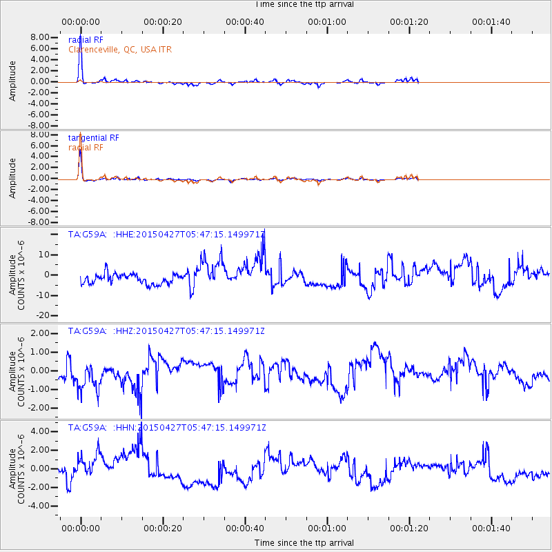
G59A Clarenceville, QC, USA - Earthquake Result Viewer
*The percent match for this event was below the threshold and hence no stack was calculated.
| Earthquake location: |
Southern Iran |
| Earthquake latitude/longitude: |
26.4/53.5 |
| Earthquake time(UTC): |
2015/04/27 (117) 05:34:31 GMT |
| Earthquake Depth: |
28 km |
| Earthquake Magnitude: |
4.8 MW, 4.8 mb, 4.0 MS |
| Earthquake Catalog/Contributor: |
ISC/ISC |
|
| Network: |
TA USArray Transportable Network (new EarthScope stations) |
| Station: |
G59A Clarenceville, QC, USA |
| Lat/Lon: |
45.08 N/73.18 W |
| Elevation: |
36 m |
|
| Distance: |
93.9 deg |
| Az: |
325.288 deg |
| Baz: |
46.151 deg |
| Ray Param: |
$rayparam |
*The percent match for this event was below the threshold and hence was not used in the summary stack. |
|
| Radial Match: |
89.73592 % |
| Radial Bump: |
177 |
| Transverse Match: |
93.57393 % |
| Transverse Bump: |
169 |
| SOD ConfigId: |
7422571 |
| Insert Time: |
2019-04-18 13:28:10.984 +0000 |
| GWidth: |
2.5 |
| Max Bumps: |
400 |
| Tol: |
0.001 |
|
Signal To Noise
| Channel | StoN | STA | LTA |
| TA:G59A: :HHZ:20150427T05:47:15.149971Z | 2.484152 | 9.094101E-7 | 3.6608472E-7 |
| TA:G59A: :HHN:20150427T05:47:15.149971Z | 2.0642445 | 1.7418157E-6 | 8.4380304E-7 |
| TA:G59A: :HHE:20150427T05:47:15.149971Z | 3.2881565 | 8.046876E-6 | 2.4472304E-6 |
| Arrivals |
| Ps | |
| PpPs | |
| PsPs/PpSs | |


