You are here: Home > Network List > TA - USArray Transportable Network (new EarthScope stations) Stations List
> Station G59A Clarenceville, QC, USA > Earthquake Result Viewer
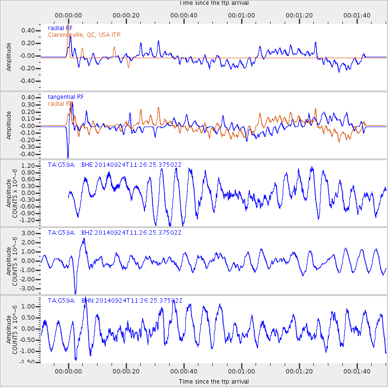
G59A Clarenceville, QC, USA - Earthquake Result Viewer
*The percent match for this event was below the threshold and hence no stack was calculated.
| Earthquake location: |
Jujuy Province, Argentina |
| Earthquake latitude/longitude: |
-23.9/-66.6 |
| Earthquake time(UTC): |
2014/09/24 (267) 11:16:12 GMT |
| Earthquake Depth: |
189 km |
| Earthquake Magnitude: |
6.2 MWP, 6.2 MWB, 6.2 MWC |
| Earthquake Catalog/Contributor: |
NEIC PDE/NEIC COMCAT |
|
| Network: |
TA USArray Transportable Network (new EarthScope stations) |
| Station: |
G59A Clarenceville, QC, USA |
| Lat/Lon: |
45.08 N/73.18 W |
| Elevation: |
36 m |
|
| Distance: |
68.9 deg |
| Az: |
354.97 deg |
| Baz: |
173.494 deg |
| Ray Param: |
$rayparam |
*The percent match for this event was below the threshold and hence was not used in the summary stack. |
|
| Radial Match: |
43.428513 % |
| Radial Bump: |
400 |
| Transverse Match: |
54.862877 % |
| Transverse Bump: |
400 |
| SOD ConfigId: |
796777 |
| Insert Time: |
2014-10-08 11:56:58.223 +0000 |
| GWidth: |
2.5 |
| Max Bumps: |
400 |
| Tol: |
0.001 |
|
Signal To Noise
| Channel | StoN | STA | LTA |
| TA:G59A: :BHZ:20140924T11:26:25.37502Z | 3.8161912 | 1.4515305E-6 | 3.8036106E-7 |
| TA:G59A: :BHN:20140924T11:26:25.37502Z | 1.2302333 | 9.991492E-7 | 8.1216234E-7 |
| TA:G59A: :BHE:20140924T11:26:25.37502Z | 2.3931239 | 9.652772E-7 | 4.0335445E-7 |
| Arrivals |
| Ps | |
| PpPs | |
| PsPs/PpSs | |


